
For live emergency information access: VicEmergency app, ABC local radio (for Ballarat – 107.9FM), or VicEmergency Hotline – 1800 226 226. In an emergency, call 000
Brown Hill FireAware Network
Do you know that Brown Hill is in a Bushfire Prone Area (BPA)?
This page is the home of the Brown Hill FireAware Network — it explains what a Bushfire Prone Area and Bushfire Management Overlay mean for your property, what the Network does, and how it’s organised. For the core guidance on preparing your home and what to do if you can’t leave, go to “What you need to know when you CAN’T leave“ which is the anchor page where all our other pages link back to.
What you will find on this page:
Do you live in a Bushfire Prone Area?
- Brown Hill location maps of Bushfire Prone Area: Brown Hill south of freeway; Brown Hill north of freeway – south of Daylesford Rd; Brown Hill north of freeway – north of Daylesford Rd
Does your property have a Bushfire Management Overlay? Bushfire Management Overlay Video
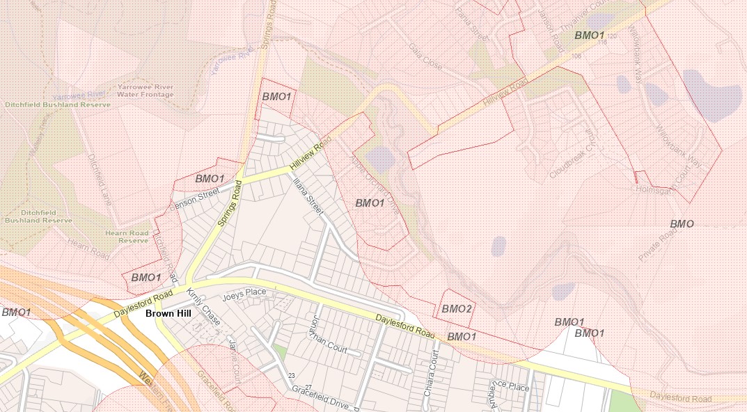
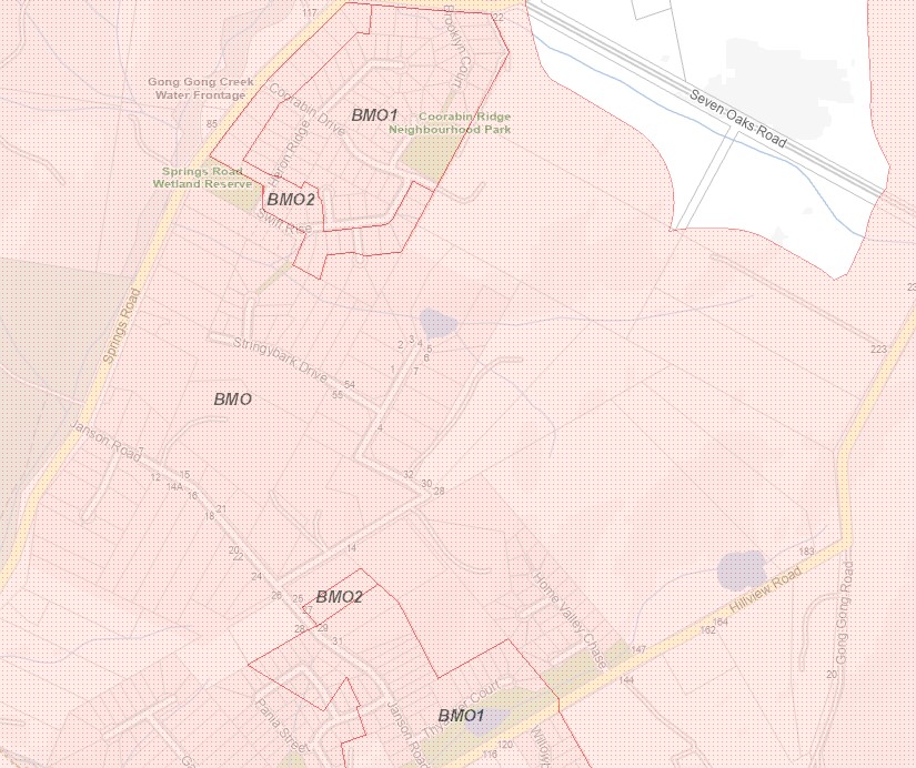
- Brown Hill location maps for Bushfire Management Overlays: Brown Hill south of freeway; Brown Hill north of freeway – south of Daylesford Rd; Brown Hill north of freeway – Daylesford Rd to Janson Rd; Brown Hill north of freeway – Janson Rd to Coorabin Estate
- Why is my house located in a BPA but does not have a BMO?
- What BMO & BAL ratings cover and what they don’t
What is the Brown Hill FireAware Network?
Know the Bushfire Danger Ratings;
Have you ever been in an ember attack?
For more detailed information access other FireAware Network pages:
- What you need to know when you CAN’T leave (anchor page); Understanding risk; Prep before you plan; Writing your plan; Neighbourhood clusters
Do you live in a Bushfire Prone Area?
A Bushfire Prone Area (BPA) is a designated mapped location identified by authorities as having a high potential risk of bushfire attack, including ember attack, radiant heat, and direct flame contact. These areas are defined by proximity to vegetation, topography, and fuel load, triggering mandatory, specialised building construction standards (BAL ratings) to improve safety. They are areas that are subject to or likely to be subject to bushfires. The vast majority of Brown Hill is located in a BPA
Brown Hill is also part of Ballarat’s urban-rural fringe. this is where the suburbs meet the bush (be it forests, bushland or grasslands). It is a chaotic, “blurry boundary” where housing, infrastructure, and human activity directly intermingle with flammable vegetation.
Many residents are unaware of this bushfire risk that this boundary creates and the responsibilities that this may impose. This zone refers to the high probability of fire igniting or spreading from natural areas to damage houses, infrastructure, and lives. This risk is increasingly significant in Australia due to suburban sprawl into high-hazard areas, climate change creating more intense fire weather, and the accumulation of fuel near homes.
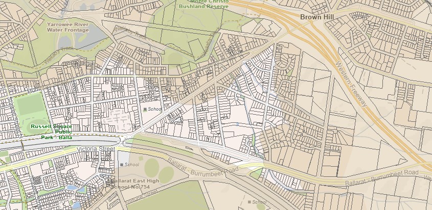
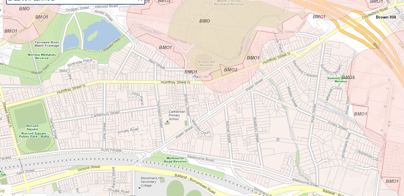
Brown Hill location maps for Bushfire Prone Areas (BPA)
Brown Hill south of freeway – significant area within BPA (the beige shading indicates the BPA)
Does your property have a Bushfire Management Overlay?
The Bushfire Management Overlay (BMO) applies to land in Victoria that may be at a very high and extreme bushfire risk which will trigger additional planning permit requirements. If your land is within the BMO you may also need a planning permit to develop or subdivide your property. Details on the exact requirements of the BMO and other bushfire planning controls can be found within your local planning scheme. Use the Department of Transport and Planning (DTP) Vic Plan Tool to find out whether your site is located within a BMO. More details can be found on this CFA link: Planning and Bushfire Management Overlay.
NOTE: Both BPA & BMO’s came into effect in Victoria in November 2011. If your house predates 2011, it is worth assuming it was built to no bushfire construction standard at all — and take this into consideration in how you think about your risk and what you can do to reduce it.
Bushfire Management Overlay video – Planning Victoria
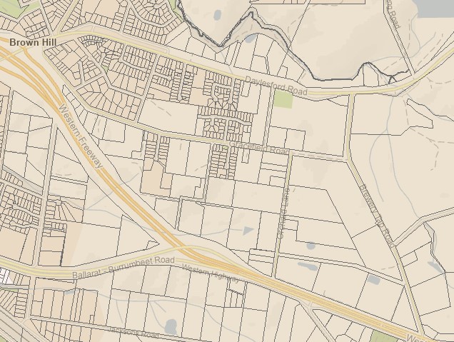
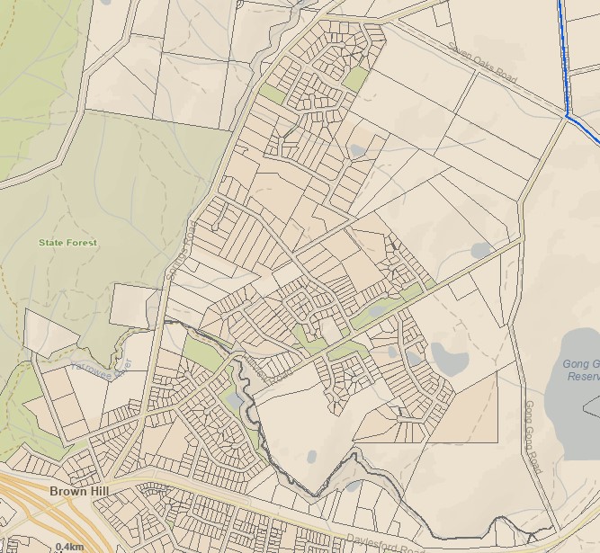
Brown Hill location maps for Bushfire Management Overlays (BMO)
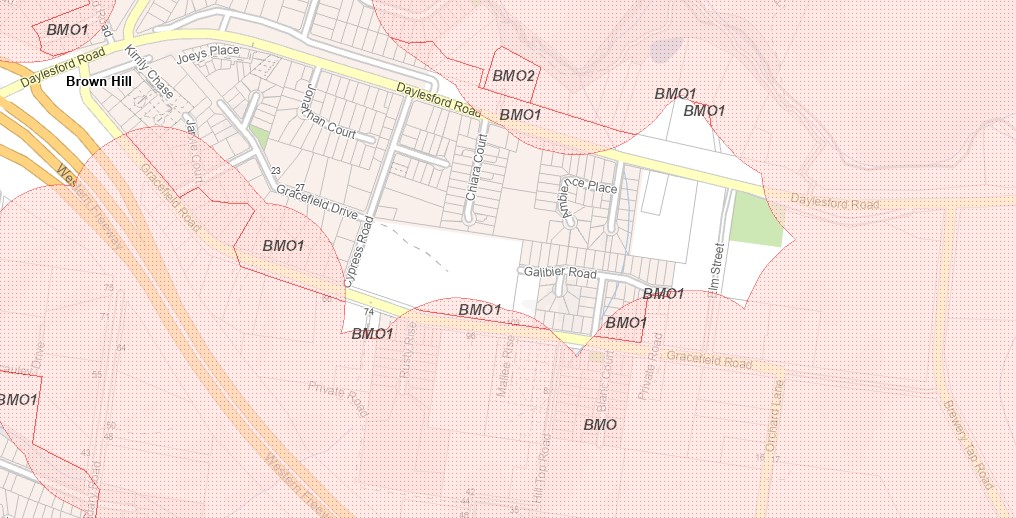
Brown Hill north of freeway – from Daylesford Rd to Janson Rd
Brown Hill north of freeway – from Janson Rd to Coorabin Estate
Why is my house located in a BPA but does not have a BMO? The BMO covers only the highest-risk areas within the broader BPA
- Bushfire Prone Areas are areas subject to or likely to be subject to bushfires — this triggers building permit requirements.
- Bushfire Management Overlay applies specifically to bushfire prone areas with very high and extreme bushfire hazards, triggering additional planning permit requirements.
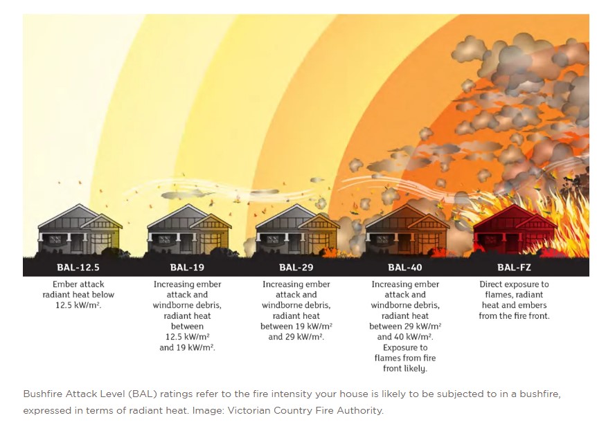
BAL (Bushfire Attack Level) ratings measure a site’s potential exposure to ember attack, radiant heat, and direct flames, ranging from BAL-LOW to BAL-FZ. They are mandatory in Australia to determine the required construction methods, materials, and building standards under AS 3959 to enhance safety and reduce fire risk. The rating helps ensure homes can better withstand bushfire conditions.
BAL ratings are essentially the foundational technical tool used to determine compliance within both Bushfire Prone Areas (BPAs) and Bushfire Management Overlays (BMOs), in Victoria. All new residential buildings in a designated Bushfire Prone Area (BPA) must meet a minimum construction standard of at least BAL-12.5.
What BMO & BAL ratings cover — and what they don’t
The Bushfire Prone Area (BPA) and Bushfire Management Overlay (BMO) maps show where bushfire risk was assessed at the time the mapping was done. They are a useful starting point — but they have real limitations that every Brown Hill resident should understand.
What the BMO and BAL system actually covers
When a house in the BMO is built or extended, it must meet bushfire construction standards set by the Bushfire Attack Level (BAL) rating for that site. That rating is based on the distance and slope between the house and classified vegetation at the time of assessment. The defendable space requirement — 30 metres, or to the property boundary, whichever is less — is set at that point.
These standards address one specific threat: radiant heat from a fire front approaching through vegetation. They were not designed to address ember attack as the primary ignition mechanism, or house-to-house ignition once neighbouring properties are burning.
What changes after construction
Once a house is built and a neighbourhood fills in, several things happen that the original assessment did not account for:
- Vegetation grows. Trees and gardens planted after construction change the fuel load around the house. The BAL rating is a snapshot, not a live assessment.
- Adjacent properties develop. Houses built on neighbouring lots become potential ignition sources for each other. The BAL system assesses a house in isolation — it does not model what happens when a neighbour’s garage catches fire.
- Secondary fuel sources accumulate. Timber fencing, bark mulch, timber decks, and wheelie bins — none of these are captured in a BAL rating — are the documented primary ignition pathways in estate fires.
- The estate fills in. What was assessed as an isolated house in a partially developed estate is now one of many houses at three to six metre spacings, with continuous fuel pathways between them.
The honest summary
Your BAL rating tells you how your house was built relative to classified vegetation when the permit was issued. It does not tell you your current fire risk.
It also does not tell you about ember attack risk across the broader neighbourhood. Embers travel kilometres ahead of a fire front — meaning properties well beyond the immediate bush edge, including across southern Brown Hill, can receive ember fall from a major fire event. And once houses begin to ignite, they become ember sources themselves. The BPA and BMO maps address bushfire from vegetation – nothing about the risk from a neighbour’s burning house.
The mapping is a useful entry point. Understanding what it doesn’t cover is what the FireAware Network web pages are for.
Dr Kevin Tolhurst AM assessed Brown Hill and estates directly and put it plainly: “Even though some of these houses in these subdivisions have been built to Australian Standard 3959, that standard is for the individual building in isolation. It’s not considering a house fire next door — it’s only considering the bushfire from vegetation. So even though you may think you’ve built your house to a high standard, it’s not necessarily going to withstand a house-to-house ignition circumstance… The greatest threat to the majority of the suburb is from ember attack… spot fires can start in multiple backyards as embers can travel long distances before a fire arrives…”
What is the Brown Hill FireAware Network?

What is the Brown Hill Community FireAware Network?
The Network was established in 2016, with support from Dr Kevin Tolhurst. The purpose of the Network is to disseminate the best available information to residents of Brown Hill concerning the bushfire risk to the suburb and how best to prepare for such an event. This information is “housed” on 7 dedicated web pages for the Network.
The Network is based on establishing discreet clusters of walk-able neighbourhoods across the suburb of Brown Hill. A priority being households on the urban-rural fringe, the designated Bushfire Prone Areas of Brown Hill. Each cluster has a key contact (a volunteer resident of the area), who acts as the information conduit between the cluster and the wider network. They distribute information; and can be a contact point for new residents.
The Network
- provides a yearly reminder of the need to prepare for the bushfire season;
- presents in a variety of ways information that is relevant to a specific neighbourhood;
- highlights that it is everyone’s responsibility to be aware and prepared to act in a fire event impacting on their community or a community nearby;
- encourages in households the “habit” of preparation.
Where residents and clusters develop their own local initiatives as a result of this information, they do so independently. The Network’s role is to provide the information — what residents do with it is their own decision and responsibility.
Clusters for the 2025/2026 fire season
There are ten neighbourhood clusters for the pre-fire season of 2026/2027. Access more details here
Six north of the freeway
- Ditchfield/Benson (approx 60 households)
- Coorabin Estate (approx. 110 households)
- Janson Rd & Stringybark Dr (approx. 150 households)
- Orchard Lane (approx. 90 households)
- Apple Orchard Estate (approx. 100 households)
- Willowbank Way
Five south of the freeway
- Mancev Crt (approx. 25 households)
- Russell Sq & Lane St (approx. 260 households)
- Finlay St Sth & Bradbury St (approx 100 households)
- Dalma/ Ryan St (approx. 55 households)
- Finlay St North (approx. 50 households)
For more detailed information access other FireAware Network pages
- What you need to know when you CAN’T leave;
- Understanding risk;
- Prep before you plan;
- Writing your plan;
- Neighbourhood clusters
- FireAware Network Resources
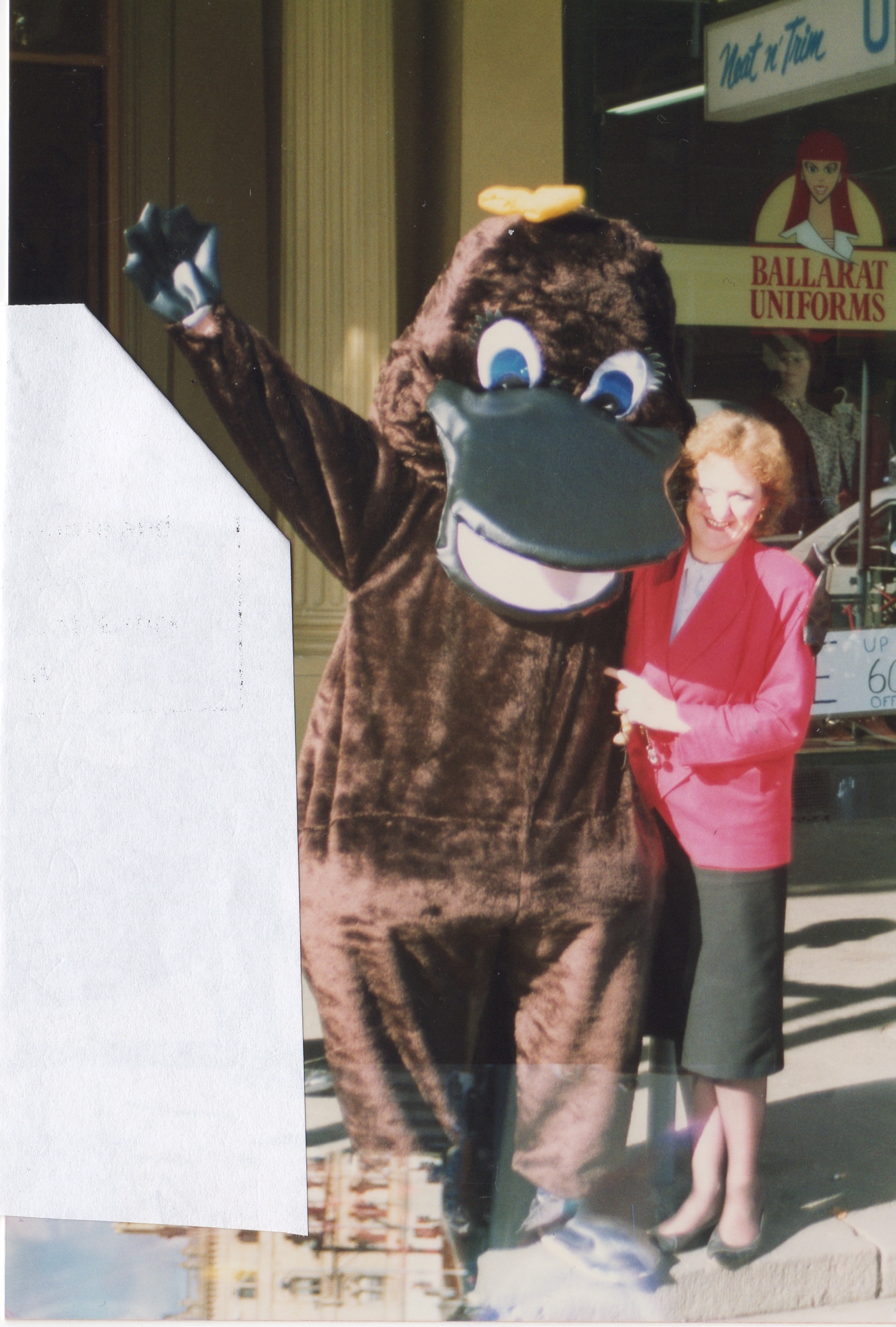
Penny Platypus above, is the mascot for the Network – learn more about Penny here
Wanting more information about the Network?
NETWORK CONTACT: Hazen – hmc433@hotmail.com
CLUSTER CONTACTS details access here
“It is the job of communities to protect their own properties. It is the job of the fire service to prevent the spread of the fire front. It is mathematically and morally wrong to expect a fire unit for every threatened house.” A NATION CHARRED: REPORT ON THE INQUIRY INTO BUSHFIRES, House of Representatives, Select Committee into the recent Australian bushfires (2003)
Bushfire Resilience Inc. an independent community-led organisation, based in Warrandyte, Melbourne
 The research behind this Network’s material comes from people who have spent decades studying what actually happens to houses and people in fire events. Bushfire Resilience Inc. webinars makes that research accessible – free, practical, and directly relevant to residents like you.
The members of BRI live in bushfire prone localities in Victoria, mainly in the Shire of Nillumbik. They have a long association with activity concerning bushfire preparedness and community resilience. They have knowledge and experience and want to help people. BRI provides carefully developed webinars about bushfire preparedness over a range of topics to assist households to make better decisions in preparing for, and responding to the threat of bushfire. Well worth of look. Register (free) for NEWS & WEBINARS
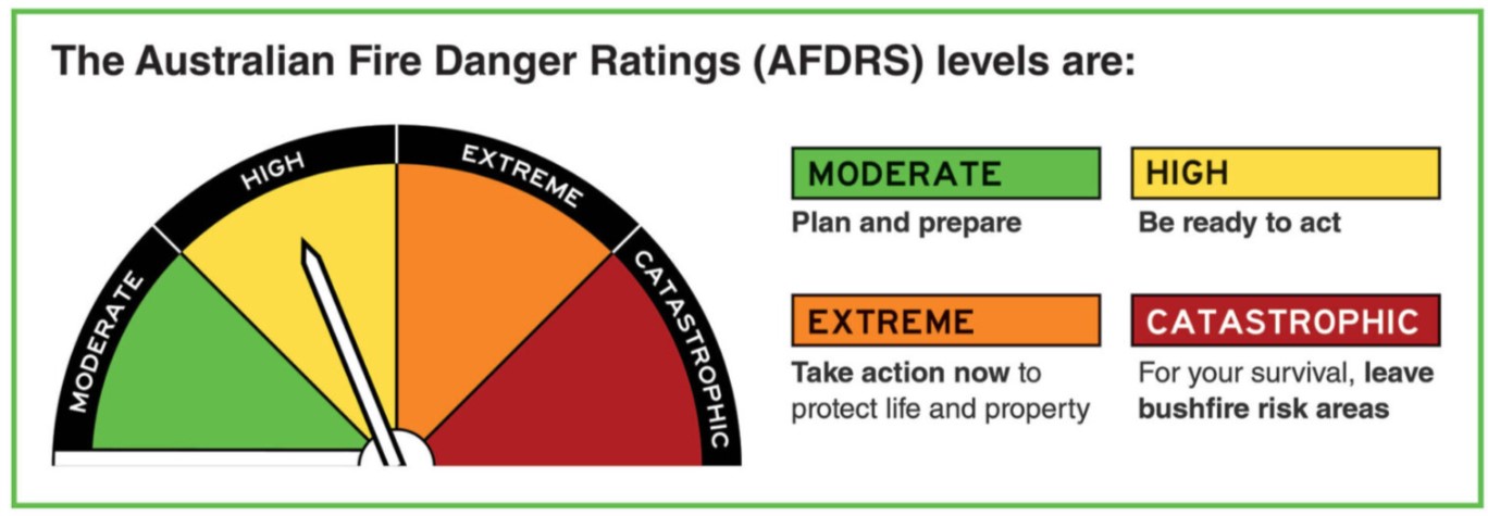
Know the Fire Danger Ratings
The fire danger rating system tells you how dangerous conditions are on any given day — and what action to take. Understanding the ratings before fire season is the difference between a decision made in advance and one made under pressure.
A Key to Understanding Your Bushfire Risk is to understand the Fire Danger Ratings. In September 2022, Australia simplified, the action-oriented fire danger rating system. The move to a simpler system was informed by extensive community consultation and backed by improvements in science, which means authorities can better predict areas of greater risk on days of fire danger. The Australian Fire Danger Rating System uses four easy to recognise rating levels, each with a message to encourage you to take action to protect yourself and others in the face of bushfire risk.
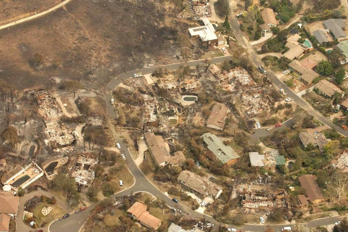
Have you ever been in a bushfire ember attack?
Unfortunately it is difficult to imagine or understand what you might face in a close encounter with a bushfire event without actually experiencing it. However we can have a glimpse by what others HAVE experienced and see it through their eyes. As embers are the primary way that houses burn in an urban-rural setting here is a video showing what an ember attack is like.
Afternoon of January 18, 2003, when four lives were lost and more than 500 homes burned to the ground. The bushfire stopped at the boundary road but the embers kept coming.
Aerial view of the aftermath of Duffy suburb hit by an ember attack
Bushfire Myths
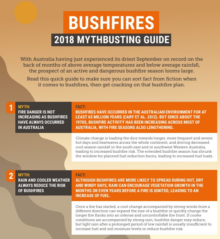
For more Bushfire Myths access this PDF from the Climate Council: Bushfire-Mythbusting 2
What support is there for the Network?
The following have offered their support to the Network in a variety of ways as a means to help raise the awareness of residents of Brown Hill of the bushfire risk to the urban interface and assist them in preparing for such an event:
Brown Hill Progress Association
Country Fire Authority (Ballarat local office)
City of Ballarat
![]() Central Highlands Water
Central Highlands Water
![]()
Dr Kevin Tolhurst (Tolhurst Bushfire Services)
In 2015 Kevin was made a Member of the Order of Australia (AM) for his significant service to science through land and bushfire management, and to the community through providing expert advice at fire emergencies. He worked and lived in Creswick and therefore had a wealth of knowledge of our local area. Kevin provided support and guidance for the Network from the very beginning until his untimely death in October 2023. In forming the Brown Hill FireAware Network, I was one of the beneficiaries of Kevin’s “superpowers”. He will be sorely missed. Hazen.
“With much sadness we heard of Kevin’s sudden death on the 5 October 2023. Kevin’s contribution to forest and fire management has been phenomenal. His knowledge and passion were truly awe-inspiring. One of his colleagues, Fire Management Victoria chief fire officer Chris Hardman said on Kevin’s passing, ‘Kevin is one of the architects of reshaping bushfire modelling in Victoria. One of his real superpowers as a highly regarded academic was his ability to take complex scientific messaging and make it so regular people could understand it.’
Gary Morgan AM AFSM; Principal Consultant; Global Wildland Fire Management Services
Gary Morgan former Bushfire CRC CEO was recognised for his significant service to the community with an Australia Day honour in 2018, Becoming a member of the Order of Australia (AM). Gary was awarded this honour for his significant service to the community through emergency response organisations, and to forest and fire research and management. He has spent more than 20 years in senior land and fire management roles. As Victoria’s Chief Fire Officer for public lands, for nine years, he was responsible for the management and deployment of fire suppression personnel. He became the CEO of the Bushfire CRC in mid-2007. He is a long time resident f Ballarat.
![]()
PLEA Network: Provider of website space for FireAware Network specific pages
Penny Platypus
The information provided through the FireAware Network’s information sessions and web pages is not for the purpose of giving specific advice. It is offered in good faith to help residents understand the potential risk to their community and make their own informed decisions. It is drawn from publicly available fire science research, expert assessments, and official guidance from fire and emergency services, and research institutions. Every property and household is different — residents should assess their own circumstances before acting.
Where any individual or collective effort is taken as a result of this information, and they develop their own local initiatives, they do so independently. The Network’s role is to provide the information — what residents do with it is their own decision and responsibility.
AFAC (Australasian Fire and Emergency Services Authorities Council). Bushfires and Community Safety Position (2019, Version 6) is a policy document for fire and emergency service agencies. Quoted here as evidence of the official evidence base underpinning this information. This document (2019, Version 6.0) was scheduled for review April 2024; no updated version located at time of web page publication.
For live emergency information: VicEmergency app, ABC Ballarat 107.9FM, or 1800 226 226. In an emergency, call 000