
For live emergency information access: VicEmergency app, ABC local radio (for Ballarat – 107.9FM), or VicEmergency Hotline – 1800 226 226. In an emergency, call 000
FireAware Network – Understanding risk of a bushfire event
Brown Hill – Bushfire Prone Area of the urban/rural fringe of Ballarat
Start here if this is your first visit
This page is a reference resource for understanding bushfire risk specific to Brown Hill: the expert assessments, the fire science, and what they mean for your street and your house. It works best once you’ve been through the anchor page first: “What you need to know when you can’t leave“ which explains the reasoning, the context, and how everything connects. The links from that page will bring you directly to the relevant section here when you need it.
- If you’ve arrived here directly, welcome, but we suggest starting there as well → “What you need to know when you can’t leave”
- Already been there? Use the section links at the top of this page to find what you need.
What you will find on this page:
Dr Kevin Tolhurst presents bushfire risk assessments for worst case scenarios for Brown Hill
- Brown Hill Community: what is our risk?
- Do you live south of the freeway? This is your risk assessment: bushfire risk south side (video)
- Do you live on a bush block? This is your risk assessment: bushfire risk for bush blocks (video)
- Do you live north of the freeway? This is your risk assessment: bushfire risk for sub division/estates (video);
-
NOTE: Post 2017 risk scenarios for Brown Hill northside: Springs Rd; Ditchfield/Benson/Hearn Rds; Janson Rd extension
What does this actually look and sound like? These accounts give you a realistic picture of what it’s like to know fire
- Black Summer interviews (video and interviews);
- The roar, why do bushfires roar?
- What it’s like when Catastrophic fire meets the urban fringe (Canberra fires 2003 – video);
- “Investigation of Bushfire Attack Mechanisms” (report); What is an ember attack? (video); Sunshine Coast ember attack (video);
- How mentally prepared are you for fire? the stress of a bushfire (video); CFA documentary on how your body will respond (video)
Now to the risk of living in an estate
- House-to-house fire scenario;
- Building to Building fire spread – the research
- The Honest Picture: Zone Zero to House-to-House Scenario
- What parts of your house are vulnerable?
- BOTTOM LINE: You need to prepare for fire days that will actually happen
- THE BRUTAL TRUTH: What you won’t know until the day, unless you read this
A note on how to read this page
The risk assessments on this page were provided by Dr Kevin Tolhurst AM, one of Australia’s most respected fire scientists. They describe worst-case scenarios under catastrophic fire weather conditions — the kind of honest, direct information rarely offered to communities. Kevin also noted that Brown Hill can be affected by smaller fires under milder conditions more regularly, and that preparation for those events is identical to preparation for the worst. “You need to prepare for fire days that will actually happen”.
Brown Hill is a diverse suburb with a range of housing styles and ages, particularly south of the freeway. The northside estates however are the most vulnerable to a bushfire event, Whatever your location, this information is provided so you can understand your risk and make your own decisions — not to replace official guidance, nor to alarm.
Brown Hill Community – what is our risk?
 In August 2017, I asked Dr Kevin Tolhurst if he could provide the residents’ of Brown Hill with an assessment of the bushfire risk to our suburb. Kevin not only provided his expertise and time but was more than happy to assist in a series of video presentations. Before you view the videos below I wish to provide some background to Dr Kevin Tolhurst:
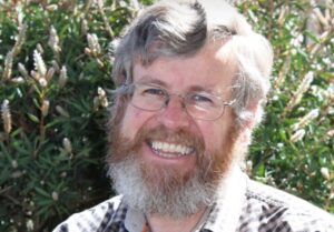
Dr Kevin Tolhurst AM was one of Australia’s most respected fire scientists. Based at the University of Melbourne’s Creswick campus, he spent decades specialising in fire ecology, fire behaviour, and the practical application of fire science to land management and community safety. (Kevin also lived in Creswick, making him a local and well versed in our bush and urban landscapes.)
Kevin co-developed the PHOENIX RapidFire model — the computer simulation now used across Australia to predict how bushfires will spread in real time — and was awarded a Member of the Order of Australia in 2015 for his contributions to fire science.
What made Kevin exceptional was his ability to translate complex fire science into language that communities could act on. Chief Fire Officers sought his counsel during major fire events. Royal Commissions drew on his expertise. And individual communities — like Brown Hill — were able to call on him to assess their specific situation and speak directly to residents about what they faced. Kevin was the Network’s “go-to-person” since its inception in 2016.
Kevin died suddenly in October 2023, following a community fire presentation in Mallacoota. The assessments he made for Brown Hill residents remain his on-the-record view of this landscape and its risks.
Kevin’s assessment was made in 2017. Fire science and climate projections since then have only strengthened his conclusions — the conditions he described as possible are now assessed as more frequent and more intense. Nothing in the intervening years has reduced the risk he identified.
Kevin’s assessments are for worst case scenarios. This first video is an introduction to the risk evaluation: 2nd video: risk evaluation for south of the freeway; 3rd video: risk evaluation for residents living on bush blocks north of freeway; 4th video: residents living in sub division/estates north of freeway. Full transcripts are available as attached PDFs.
Brown Hill bushfire risk evaluation introduction – VIDEO 1:
AUGUST 2017: Alice, a Neighbourhood Cluster Contact for the Brown Hill FireAware Network, talked with Associate Professor Kevin Tolhurst about some key points relating to the bushfire risk to the Ballarat urban-rural fringe suburb of Brown Hill. (Note fire danger ratings have been updated to current terminology in transcripts – e.g. Code Red is now Catastrophic)
To view the Bushfire Prone Area of Brown Hill access the link here. Source: Visualising Ballarat. What are Bushfire Prone Areas? Bushfire Prone Areas are areas that are subject to or likely to be subject to bushfires. Access your own property report from Vic DELWP’s Vicplan website
Brown Hill bushfire risk for residents living south of the freeway – VIDEO 2:
Key points from Video 2:
- Brown Hill, Nerrina, and Invermay are actually in the potentially worst bushfire area in the Ballarat area;
- Under Catastrophic or Extreme fire weather conditions, a fire that starts near Creswick or Clunes and comes down to the west of this area here has the potential to build to quite a scale with large showers of embers hitting the suburb;
- Embers provide a massive threat to this particular area with the potential for a lot of backyards catching fire from spot fires;
- Houses close together (as in Brown Hill) are the main risk of house-to-house ignition;
- In a major bushfire event, there aren’t enough firefighters and fire trucks to protect all the houses — so the chance of house-to-house ignition is quite pronounced in an area like this;
- So you really need to be talking to your neighbours, It really needs to be a neighbourhood effort trying to prepare your house;
- All of these things have to be done well in advance of the fire season. You can’t do it on the day a fire has started;
- That’s true in a big fire event. But will also be subjected to more smaller fires under milder conditions on a more regular basis – which would be easier to deal with, but still potentially life-threatening with houses lost;
- What you need to do to prepare for that sort of fire, is consistent with what you need to do in a larger fire event;
- You shouldn’t be feeling “I’ll just leave if it’s a major event,” because you could get caught up in a fire that occurs quite quickly over a short period of time and won’t have time to leave; At the same time, all of that preparation is really good preparation for a much more major event, where you’re going to need to be much more self-reliant;
- And under those really severe conditions, the roads out of the area will be limited very quickly. So the ability to leave the area will be limited — and that means you really need to have a lot of preparations made well before any fire arrives.
Embers are the main initial threat
ACCESS THE FULL TRANSCRIPT HERE: VIDEO 2 Dr Kevin Tolhurst risk assessment southside
Brown Hill bushfire risk for residents living on bush blocks – VIDEO 3:
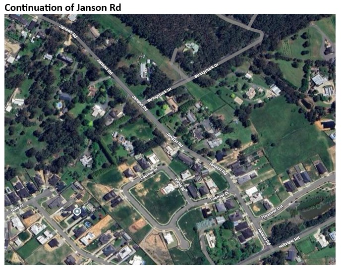
NOTE: In this video it is mentioned that Janson Rd and Stringybark Drive have only one entry and exit point onto Springs Rd. Since the video was made in 2017, Janson Rd has extended over the hill and enters Hillview Rd. Hillview Rd however also feeds into Springs Rd. The extended Janson Rd now has many smaller urban housing estates feeding into it.
The new estate housing changes the risk profile from bush blocks to close-packed urban housing, the same as Coorabin and Apple Orchard. So it combines the worst of both scenarios — direct fire front (bush blocks), and ember exposure to house-to-house ignition risk of estate density. Egress is also compromised further. This note is added by the Brown Hill FireAware Network, March 2026.
Key points from Video 3:
- The main difference between these bush blocks and the older established part of Brown Hill is that here, the houses are well separated — so the chance of house-to-house ignition is relatively minimal…however, fire is able to move freely through this landscape;
- As fire crests the hills (from north / west) it will throw embers and start spot fires. You could potentially have hundreds of ignitions starting within a few minutes across this area. The potential for fire impact here is quite high;
- Along with that, access and egress would be seriously compromised... The chance of a tree coming across the road, or a powerline coming down, would severely compromise your ability to get in or out (Refer to note above);
- Given the potential for large numbers of spot fires starting across this area, it would be really important to have your house and your land well prepared in advance of the fire;
- You have an additional consideration here as well: under conditions that might be just High or Extreme fire weather — not only Catastrophic — you could still have quite a significant fire in this location. You are actually right in a bushfire;
- Firstly, know what you are actually going to do — and your family’s role in that; secondly, plan what you’re going to do with any animals;
- You also need to plan how you’re going to defend your house in the event that it’s not a major fire, but a fire has started perhaps a kilometre away and your house is likely to be impacted;
- Everyone in the family has to know what they’re expected to do. That sounds simple — you can talk about it — but talking about it is really not enough – you need to document what you’re planning to do and practice it;
- In serious fire situations you end up in darkness, it can become completely dark in the middle of the day. If you are NOT prepared thinking you’re going to work all of this out an hour before the fire hits is simply a pipe dream it’s not going to happen;
- Be involved in your local community, talk about these things, look at websites with useful resources, getting yourself as well informed as possible is key;
- No two fire situations are the same, and they are horrendous enough at the time, but when you already know some of the things that ARE expected it makes the unexpected things a little easier to deal with.
Fire moving through your location is the main threat
ACCESS THE FULL TRANSCRIPT HERE: VIDEO 3 Dr Kevin Tolhurst risk assessmen tbush blocks
Brown Hill bushfire risk for residents living in sub division estates northside – VIDEO 4:
Key points from Video 4:
- Housing is urban in the sense that the houses are relatively close together, but the houses are then situated in a rural setting;
- Under Extreme or Catastrophic weather conditions, a fire could start out towards Creswick or Clunes — 20, 30, 40 kilometres away — and develop to quite a large size and then impact on this area, which is quite different to living in the centre of Ballarat;
- When the fire runs up the hills and across the divide here, those hills act as a launch ramp to throw massive numbers of embers forward;
- Estates in this Brown Hill area, could potentially just be bombarded with embers leading to spot fires which will be in people’s backyards, in parks, on roadsides —within a few minutes, the whole area will basically have fire in it;
- That’s part of what people living in an area like this would need to deal with on that day, and it will add to the confusion as to what you’re able to do;
- Within the subdivision itself, there would be a lot you could do to defend your property, because you’ll be dealing with small fires to start with — it’s not a big fire front. But it’s going to go on for hours, so you have to have a fair amount of stamina;
- The house, is the biggest fuel load of all in the environment, it’s not the bush;
- You have to be much more self-reliant — either through design or through your own protective action – talk to your neighbours;
- There needs to be a community effort to make the community as safe as possible;
- When houses are closer than about ten metres to each other, they become a real threat for their neighbours;
- Even though you may think you’ve built your house to a high standard, it’s not necessarily going to withstand a house-to-house ignition circumstance;
- So people need to be preparing. Talking to their neighbours to come up with a way of dealing with it;
- Limited exit roads which can easily become blocked, can prevent you from leaving. If you haven’t done adequate preparation in your neighbourhood or at least on your property, then you haven’t got anywhere to go to. So it’s really important to prepare your house even if your plan is to leave;
- Even under high or even severe conditions a fire may start quite close to you and within an hour be impacting your property. If you haven’t done your preparations it’s going to be even harder in these milder conditions to defend your property;
So regardless of whether you think you may or may not be subjected to a Catastrophic fire — chances are you will be subjected to a bushfire of lower intensity, and you need to be prepared for either eventuality. Have a back-up plan.
ACCESS THE FULL TRANSCRIPT HERE:VIDEO 4 Dr Kevin Tolhurst risk assessment estates northside
NOTE: Post 2017 risk scenarios Brown Hill northside
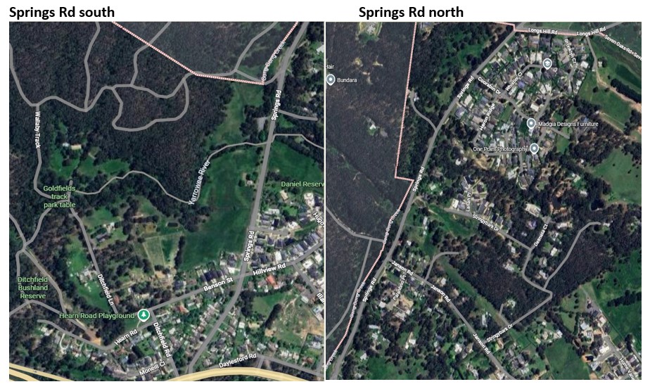
Since Dr Kevin Tolhurst’s risk assessments in 2017 the northside area has substantially changed with in-fill estates between Springs Rd and the Gong-Gong Reserve & Daylesford Rd. This has highlighted a distinct subset of northside housing that sits on or adjacent to the western edge of the northside area:
- mixed housing along Springs Road
- older housing within the Benson/Ditchfield/Hearn Rd area
- newer estate housing where Janson Rd (from the crest) has been extended to Hillview Rd
These properties could face a mixed threat profile differing from the estates that Kevin was primarily focusing on in Video 4.
As the images below show:
- Springs Rd: Has a mix of older bush blocks as well as newer housing on smaller (estate size) blocks. The northern end of Springs Rd faces directly onto the bushland of the Creswck Regional Park. At the southern end from Yarrowee River crossing to Benson Rd there are open paddocks. Newer estates coming off Hillview Rd are directly behind Springs Rd housing.
- Benson/Ditchfield/Hearn Rds: West of Springs Rd at the southern end, are the older established houses on slightly bigger blocks. The Ditchfield Bushland Reserve lies west of this area.
- Janson Rd extension: Kevin’s assessment focussed on the bush blocks that extended to the crest, where the road in 2017 stopped. Kevin’s assessment included the potential for a fire front to carry through these bush blocks. With the extension of Janson Rd to Hillview Rd this section now contains closer spaced estate housing. If a fire entered the bush blocks, the dynamic of a fire would change when it reached the crest. Residents in this area would need to be aware of such a possibility. Though exactly how has not been separately assessed.
As I have been unable to obtain an authoritative risk assessment for these mixed profiles, I would suggest that for residents living in the above locations, when considering their particular fire risk, they need to factor in both a fire front scenario as per Janson Rd bush blocks (video 3) with the estate housing scenario (video 4) depending on their location and housing type. Regardless of what residents may face, the need for prior preparation is the constant for ALL housing in Brown Hill.
What does this actually look and sound like? These accounts give you a realistic picture
The videos and accounts below show what a bushfire event actually looks, sounds and feels like. Most Brown Hill residents have no prior fire experience — these are as close to a rehearsal as you can get without being there.
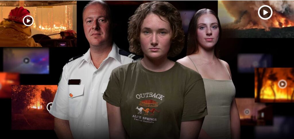
What it’s like to know fire: Black Summer interviews
ABC News, Four Corners, February 2020: “Life-or-death moments caught on video brought the terror of the Australian bushfires into people’s homes around the globe. Unlike previous bushfires, the crisis was captured by thousands of people posting footage in real time from inside the inferno. Some extraordinary moments have been viewed tens of millions of times, but who filmed them and how did their stories end?” Access interviews & footage here Keep scrolling down the page for interviews and footage on the day. The first interview is the important one for you, as it shows what it is like experiencing a bushfire for the first time. REMEMBER TO TURN ON THE AUDIO – Loud is best.
The first interview, Behind the Burnt Hose: India MacDonell, 19, and her father Shaun lived “the sweet life” on a small farm in East Gippsland, Victoria. Shaun had fought to save the house before and this time his tenacious daughter was determined to help him defend the property she had grown up on. On December 30, India watched from their roof as the fire approached and thought it looked “almost spectacular”. But the firestorm was far worse than they had expected. And it was the first time India had used a fire hose.
The roar, why do bushfires roar?
One thing survivors consistently describe — and that no checklist prepares you for — is the sound.
The most common description is that of a freight train, a jet engine, or a loud, continuous roar that gets louder as the fire approaches. One survivor described it this way, “the noise is not just sound, but a “whole-body experience” combined with extreme heat, violent wind, and thick smoke. What causes this “roar”? It’s caused by a combination of rapid chemical reactions, violent physical changes in burning vegetation, and massive air turbulence. Here are some of the primary causes of the noise in bushfires:
- Rapid Gas Expansion & Combustion: As fire heats vegetation, the cellulose and other materials turn into volatile gases. When these released gases mix with oxygen and combust, they expand violently, producing intense sound waves.
- Boiling Moisture in Wood (Crackling/Popping): Plants and wood contain water and sap inside tiny pores. When heated, this moisture turns to steam, increasing internal pressure until the wood splits, releasing the gas in a “pop”. A higher moisture content in the fuel generally leads to more noise.
- Air Turbulence (Roaring Sound): The extreme heat of the fire creates massive updrafts as hot gases rise quickly and air rushes in to take their place. This constant, violent rushing of air creates a low-frequency, roaring sound, similar to wind turbulence.
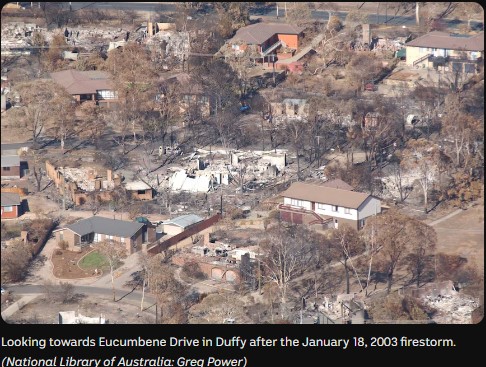
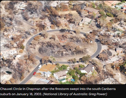
What it’s like when a catastrophic fire meets the urban fringe – 20 years on
The Canberra 2003 fires are the closest Australian reference case to what a northside estate fire event could look like. The suburb of Duffy – predominantly large houses, medium-density blocks, timber fencing, gardens with combustible ground cover, and proximity to bushland.— is the same housing situation as Brown Hill northside.
The bushfire that changed Canberra forever
January 18, 2023, ABC NEWS: “It’s been 20 years, but Canberra’s devastating bushfires remain seared into the city’s consciousness. On the afternoon of January 18, 2003, four lives were lost and more than 500 homes burned to the ground. Many residents still reflect on their own narrow escapes, and some question why the city wasn’t adequately warned.”
Why this matters for Brown Hill northside: The Duffy suburb shares key characteristics with the northside estates: predominantly large houses, medium-density blocks, timber fencing, gardens with combustible ground cover, and proximity to bushland. The fire mechanisms documented in the report below are directly applicable. Dr Kevin Tolhurst specifically referenced Canberra 2003 in his Brown Hill risk assessment.
You can see what houses burnt BUT also see what houses did not burn
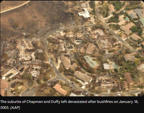
Leonard & Blanchi (2005): Investigation of Bushfire Attack Mechanisms Resulting in House Loss — ACT Bushfire 2003
The research behind the Canberra case is documented in a CSIRO field survey — the most detailed post-fire building analysis conducted in Australia. The findings directly apply here.
Source: Raphaele Blanchi and Justin Leonard, CSIRO Manufacturing and Infrastructure Technology (CMIT). Prepared for the ACT Coroner’s Inquiry. April 2005. Draft CMIT Document. Access full report here: Investigation of Bushfire Attack Mechanisms 2005 report
This is a primary source document. It is the field survey report on which Justin Leonard’s subsequent work, BRI webinar presentations, and Australian post-fire research methodology are based. 229 houses were surveyed in the Duffy suburb of Canberra following the 18 January 2003 fires Following are extracts relevant to Brown Hill and northside estates in particular.
Section 5.4 “Research has shown that human activity plays an important role in mitigating the risks (prevention and suppression activities, before, during and after ember attack). If the small ignitions made by embers are not extinguished, they can grow to involve the whole building.”
Section 6.2 documents house-to-house ignition as a significant secondary mechanism. Key findings:
- Burning houses produced sustained radiant heat and flame contact on adjacent structures for an hour or more — far longer than the few minutes of the fire front passage
- Timber fences were identified repeatedly as the direct pathway for fire to spread from one structure to another
- Outbuildings (garages, sheds) were lost at higher rates than main structures, and then became ignition sources for the main structure
- The report identifies “the placement of relatively large houses on medium sized blocks, and the presence of timber fences and vegetation between the closely aligned structures” as key aggravating factors
Section 6.2 — critical finding: “It was highly likely that if no suppression activity occurred during this time, the house loss would have approached 100% in the surveyed area.” The surveyed area had 47% of houses destroyed. The report assesses that without the combined community and agency suppression activity that occurred during the four-plus hours after the fire front passed, loss would have approached 100%.
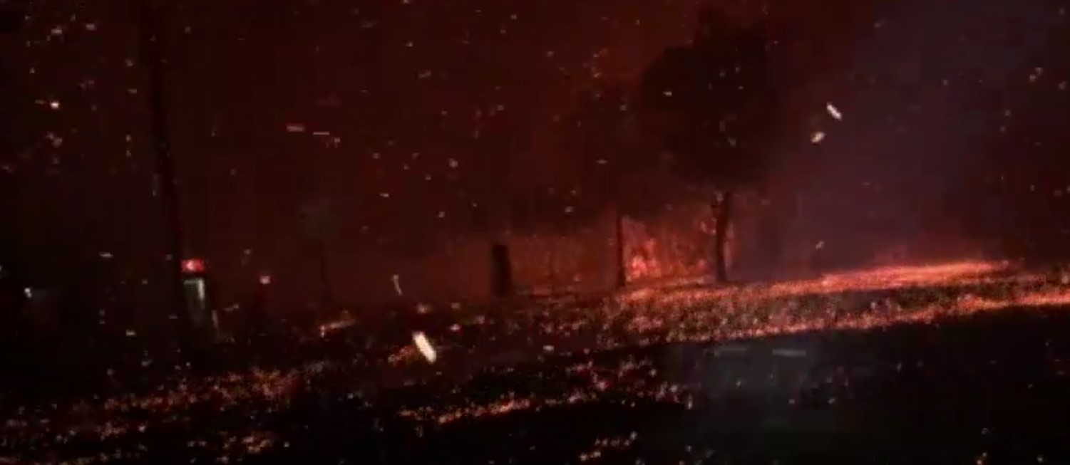
What is an ember attack?
Understanding what embers actually are — and how they behave — is the foundation for understanding why preparation actions on the ember-proofing page matter.
I thought this description of an ember attack helpful: “I tended to think of embers as a single thing that might get in and start a fire. But in fact, embers come like a sandstorm and they build up against things and so, in the end, you’ve got this red-hot stuff that’s actually going to ignite your window frame, or your mulch, or whatever it happens to land on.” Malcolm Hackett, OAM
Embers accumulate in the same places as sand, snow, winter leaves around your house. It is the strength of the wind and wind gusts that can drive embers into gaps and crevices hard to be believed.
- Embers are burning twigs, leaves and pieces of debris
- Ember attack occurs when twigs and leaves are carried by the wind and land on or around houses
- Ember attack is the most common way houses catch fire during bushfires
- Embers can land on top of debris in your gutters and set fire to your house
- Ember attack can happen before, during and after the bushfire
ABC News video: 9 September 2019: Ember attack during bushfire on the Sunshine Coast. Click on image below
How mentally prepared are you for fire?
Preparing yourself psychologically or emotionally to cope with a bushfire is as important as the preparation of your home and surroundings. The Country Fire Service of SA have produced an excellent web page that outlines the important aspects of emotional preparation for a bushfire event that residents need to consider.
The stress of a bushfire
In developing your Bushfire Survival Plan, it is important to understand the threat a bushfire places you in: on high alert – this allows you to respond rapidly to urgent situations but it can cause stress if it continues for extended periods; under stress – defending your home can be a long and exhausting process.
How we respond to the initial threat and manage the stress will be different for each of us. Recognising the signs of stress, and understanding how you manage your responses will help your decision-making and bushfire preparation.
The following video “Bushfires will happen again – Conversation with…” series is a collection of video shorts produced by the South Australian Country Fire Service (CFS) designed to promote community awareness, preparedness, and psychological readiness for bushfire season – help residents
- Real-Life Stories: The videos feature conversations with residents or business owners—such as Jack in the Adelaide Hills or John at Sampson Flat—who experienced catastrophic fire days (specifically highlighting the 2015 fires).
- Focus on Reality & Complacency: The central theme is that bushfires are inevitable (“will happen again”) and that complacency is a major danger.
- Emotional & Practical Impact: They highlight the emotional trauma, the “darkness” of smoke, and the necessity of having a prepared and actionable bushfire plan.
- Community Preparedness: The campaign encourages residents to take responsibility for their own safety by understanding that they may need to make fast decisions when a fire approaches.
October 2011: This video explains how a bushfire impacts you mentally and emotionally, and what to do to help your chances of both survival and recovery. Dr Rob Gordon, OAM, psychologist and trauma expert. Rob also worked with Scotsburn fire survivors locally in 2015. Source: CFA documentary
Now to the risk of living in an estate: House-to-house fire scenario
Once fire reaches an estate, the bush is no longer the primary threat. The houses are.
The house-to-house problem has no individual solution – only collective ones. Leonard’s research establishes that at estate separations of 3-6 metres; a single burning house can directly ignite the next. Tolhurst named this explicitly: “when houses are closer than about ten metres to each other, they become a real threat to their neighbours.” This is not addressed by AS 3959 – the building standard addresses the fire front from vegetation, not the house next door.
Once a house is burning, it generates sustained radiant heat on adjacent structures for an hour or more — far longer than the passage of a fire front. Even though you may think you’ve built your house to a high standard, it’s not necessarily going to withstand a house-to-house ignition circumstance. It is therefore important to understand this specific risk to where you chose to live, either intentionally or not.
There is however a scientifically grounded lever that urban-rural fringe estate residents, in this specific housing type can employ, and it is more effective than most people assume. It is preparing their home and property according to the “Home Ignition Zone” guidelines and to ember-proof their home. Which is discussed in detail here The principle being that if each prepared household minimises ignition of its own property it helps to reduce ember and radiant heat load on its neighbours and minimises combustible fuel loads between houses. This could collectively lower the risk of a house to house scenario happening.
Definitions: The Home Ignition Zone is the area immediately surrounding your house — out to about 30 metres, but most critically the first 1.5 metres — where embers land and ignite things. Ember-proofing a home to bushfire embers means making physical changes – before the season – that reduce the ways embers can get into your home or take hold. It is work done in advance, not on the day. The immediate 1.5m zone around a house is called Zone Zero. REMEMBER: Houses burn from the inside out.
Dr Kevin Tolhurst, extracts from risk assessment: “One of the things that is likely to happen — and we have the experience of the Canberra fires in 2003 and more recently the Wye River Fire in 2015 — is that a lot of the houses were lost from house-to-house ignition. People’s gardens are burning, sitting close to their house, and the house itself is the biggest fuel load in the environment, unless you’re able to stop one house’s fire from spreading to the neighbour’s house.
Building-to-building fire spread: what the research says about close-packed estate housing
Most fire safety guidance addresses the threat from the fire front — the approaching wall of flame from the bush. In northside estate housing, that is not the primary threat to your house. The primary threat is the house next door.
Once a house ignites and burns fully, it becomes a fire source in its own right — generating intense heat, flames and embers that directly threaten the structures immediately adjacent to it. This is what researchers call building-to-building fire spread. It is the mechanism documented after Canberra 2003, Lahaina 2023, and Los Angeles 2025 — fires that destroyed not just houses near bushland, but whole neighbourhoods deep inside the urban area.
What the experiments actually show
The Insurance Institute for Business and Home Safety (IBHS) — an independent, non-profit research organisation — spent four years conducting full-scale experimental testing of building-to-building fire spread. Real structures. Controlled wind conditions. Measured heat delivery at precise separation distances. The results were published in the peer-reviewed journal Fire Technology in January 2026.
The separation distances tested map directly onto northside estate housing.
At 3 metres separation: destruction of the neighbouring structure was essentially certain. Fire-resistant building materials provided no meaningful protection at this distance. Ignition occurred within approximately 10 minutes.
At 6 metres separation: outcomes became variable. An unprotected structure still faced high failure probability. However, structures with hardened features — non-combustible siding, enclosed eaves, double-glazed tempered windows — showed substantially reduced ignition likelihood. The researchers concluded that at 6 metres, these retrofits can “substantially reduce ignition likelihood and help break the chain of conflagration.”
At 9 metres: ignition risk was substantially reduced across all building types tested.
At 12 metres: only cosmetic damage was recorded under the tested conditions.
One finding the researchers did not expect deserves specific mention. At high wind speeds, even heat exposures above 100 kW/m² — an extreme level — did not always cause immediate ignition. The reason: wind-driven convective cooling of the target building was simultaneously interrupting heat delivery. The same wind that drives the fire also partially limits it.
Why cascades slow and stop
A burning house does not maintain peak heat output throughout its burn. When structural elements collapse — roof sections giving way, walls failing — the collapse reshapes the flame, restricts airflow, and causes sharp drops in heat intensity. In one experiment at 6 metres separation, structural collapse caused intensity to drop so sharply it took 8 minutes to recover, by which time much of the fuel was consumed.
This matters because it means building-to-building spread is not a steady, unstoppable progression. It is an uneven process, interrupted by collapse events, moderated by wind, and ultimately limited by finite fuel. Every house has a defined fuel load. Once consumed, heat output declines. The cascade eventually loses the sustained energy it needs to continue.
This is experimental evidence, not modelling or theory.
The question worth asking
For residents in close-packed estate housing, the individual question — will my house survive? — is incomplete. The research points to a different and more useful question: “What slows the cascade across a group of houses?” & “Will my street survive?”
The answer the research supports is this: every house that delays its own ignition reduces the sustained heat energy delivered to the next structure. A hardened house at 6 metres does not become fireproof, the research is explicit that it does not. But it changes the probability of ignition, and when/if it does eventually ignite, it reaches full involvement later. That delay matters to the next house, and the house beyond that.
The researchers conclude that for existing dense communities — where separation distances cannot be changed — the response is to maximise hardening and minimise connective fuels. No single measure is sufficient. The effect is collective and cumulative.
A street where most houses have addressed the highest-priority vulnerabilities — the garage, the fence-to-wall junction, bark mulch against the house, unprotected vents and eaves — is a street where the cascade loses energy more quickly. Not a street where fire cannot spread. A street where it spreads more slowly, runs out of sustained fuel sooner, and leaves more houses standing.
Your prepared house protects your neighbours. Their prepared house protects you. This is not a figure of speech. It is what the experimental evidence shows.
Source: Hedayati, F., Gorham, D., Monroy, X., Marandi, M., Sluder, E., Gollner, M., Cui, W. & Merhi, A. (2026). Wind-Driven Building-to-Building Fire Spread: Experimental Results and Probabilistic Modeling. Fire Technology, 62, 32. Published January 2026. Funded jointly by the California Department of Forestry and Fire Protection (CAL FIRE) and IBHS. Peer-reviewed, open access.
The application of these findings to Brown Hill northside estate spacing (typically 3–6 m) is a direct application of the paper’s documented findings to local conditions. It is not claimed as a finding of the paper itself.
The Honest Picture: Zone Zero to House-to-House Scenario
The 12/13 Metre Threshold
Justin Leonard’s research identifies approximately 12 metres as the threshold below which a burning house can directly ignite its neighbour through radiant heat alone — without any embers involved. Most northside estate houses sit at 3–6 metre separations.
Does Zone Zero Get Cancelled Out by a Burning Neighbour?
The honest answer: partially, but not entirely — and the timing matters enormously. Zone Zero and house-to-house radiant heat operate in sequence, not simultaneously.
Phase 1 — Ember attack (before any house is fully involved)
This is where Zone Zero does its full work. Embers arrive first — potentially well before any neighbour’s house is burning. A well-prepared Zone Zero significantly reduces the chance of your house being the first to ignite. If your house doesn’t ignite first, you don’t become the radiant heat source for your neighbours.
Phase 2 — One neighbouring house becomes fully involved
Radiant heat is now added to ember attack. At 3–6m separation, BAL 29 glazing (5mm toughened glass) will eventually fail under sustained radiant heat from a fully involved structure — it was rated for bushfire radiant heat loads from vegetation, not a neighbouring house fire burning for 60+ minutes. Zone Zero still matters because it removes secondary ignition pathways — fence junctions, decks, mulch — that accelerate heat transfer to the structure. But it cannot neutralise direct radiant heat load at close range.
Phase 3 — Multiple houses involved
This is Tolhurst’s domino scenario. Individual property preparation cannot hold the line alone at this stage. This is the scenario that exceeds individual response capacity.
How BAL 29 Responds to a Burning Neighbour
In northside the majority of houses would have a BAL 29 rating which is rated for bushfire radiant heat up to 29 kW/m² from vegetation at distance. A fully involved house at 4 metres generates radiant heat loads significantly exceeding this — research estimates suggest 40–80 kW/m² at close range from a burning structure. BAL 29 buys some time.
- The 2mm mesh screens will still exclude embers — that function persists
- 5mm toughened glass will resist initial radiant heat but is likely to fail under sustained load from a close burning structure
- Once glazing fails, the interior is exposed to both radiant heat and ember entry simultaneously
Self-Extinguishing Street — Leonard’s Key Finding
Leonard’s post-fire surveys consistently show two distinct street-level outcomes. This is the most directly relevant finding for northside residents:
| Streets that survive | Streets that collapse |
| Houses are ember-resistant | Timber + timber + close spacing + embers |
| One house igniting does NOT ignite the next | One fully involved house throws heat and debris onto the next |
| No continuous fuel path between houses | Cascade failure faster than crews can intervene |
| Metal fences, hard landscaping, concrete gaps | Timber fences, bark mulch, decks connecting to fences |
This is not about bush proximity. It is about house-to-house compatibility. The difference between a street that survives and a street that collapses is determined by individual property choices — collectively. i.e. the street gets its best possible chance of surviving through individual collective action.
The “why bother” question deserves a direct answer: Zone Zero preparation cannot protect you from a fully involved neighbouring house at 3 metres. Nothing at an individual property level can. What it does is: (1) reduce the chance your house ignites first from embers, before any neighbour is involved; (2) slows the ignition process if radiant heat is building, buying time; (3) collectively, if enough houses in the estate are prepared, it reduces the probability of the first ignition that starts the cascade. Your Zone Zero preparation matters most to your neighbours. Theirs matters most to you.
What parts of your house are vulnerable?
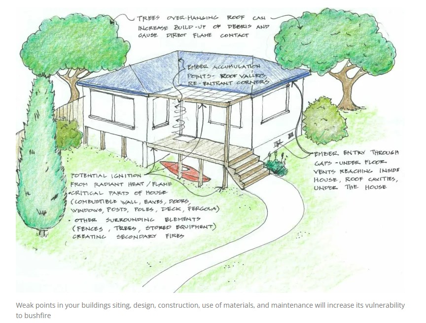 Understanding which parts of your house are most at risk is the first step to reducing that risk. Some vulnerabilities are obvious; many are not.
Your homes vulnerability refers to the extent to which it is likely to be damaged or disrupted by the impacts of a bushfire. In other words, how vulnerable it is to the hazards present during a bushfire. Your level of vulnerability is determined by the type and number of weak points that all other things being equal, make your home more likely to be damaged. The greater your level of vulnerability, the greater the risk. Source: CSIRO Bushfire Best Practice Guide
What parts of the house are vulnerable to bushfire?
- Any gaps where embers can enter and ignite combustible elements (inside the house, roof cavities, wall cavities, under the house).
- Any corner where embers and debris can accumulate and ignite (including around doors, decks, and window sills).
- Any vertical surface that is exposed to heat, flames or intense ember attack (including windows and combustible walls, eaves, doors, posts and poles).
- Any combustible horizontal surface where embers can accumulate (including decks, roofs and pergolas).
The Bottom Line: You need to prepare for fire days that will actually happen
Every fire safety message you will hear focuses on the worst-case day — the kind that generates a royal commission. That framing, while not wrong, can work against preparation. If the only fire worth preparing for is one that may never arrive in your lifetime, it is too easy to put it off.
Here is what the data actually shows. Since Australia’s current fire danger rating system was introduced in September 2022, Victoria has recorded Catastrophic fire danger on just a handful of days across two fire seasons. Extreme fire danger days have been recorded roughly seven to ten times per season — approximately once a fortnight through the fire season, somewhere in Victoria.
The historical record tells the same story. Looking at Victorian fire events with significant documented house losses or fatalities since 1983, roughly twice as many occurred under Extreme conditions as under Catastrophic. The 1997 Dandenong Ranges fires (43 homes destroyed, 3 deaths), the 2015 Wye River fires (116 homes) — both Extreme days, not Catastrophic ones.
Associate Professor Kevin Tolhurst, who assessed the Brown Hill, specifically, said it directly: “We shouldn’t just be focused on Catastrophic conditions — even under High or Extreme fire danger ratings we could have hundreds of houses lost.” — Dr Kevin Tolhurst AM, BRI Webinar 4, 2021
The preparation is identical either way. Every action that reduces your risk on an Extreme day — ember-proofing the garage, replacing bark mulch, knowing your triggers, having a written plan decided in advance and practiced — is exactly the same action that gives your house its best chance on a Catastrophic day. There is no version of preparing for Extreme that leaves you worse off if Catastrophic arrives.
Preparing for the realistic and frequent event also builds the habits and the mental readiness that serve you on the worst days. Preparing only for Catastrophic — a day most Brown Hill residents will never personally experience — tends to produce paralysis rather than action.
The trajectory is also worth understanding. Extreme fire weather has increased over the past 30 years in southern and eastern Australia and is projected to continue increasing. The 9 January 2026 event — Ballarat’s highest temperature for that date on record, with wind gusts approaching 90 km/h — was not an outlier. It was the kind of day that is becoming more common. Fire seasons are also lengthening.
The honest summary: Catastrophic days make history. Extreme days will actually test your preparation — more often, and probably sooner than you expect. The preparation for both is the same thing.
How we know this: Fire danger day counts (Extreme and Catastrophic, 2022–2026): planningforfire.com.au; drawing on Forest Fire Management Victoria and Bureau of Meteorology records. Victorian bushfire event list (1983–2026): compiled by the FireAware Network from BoM historical records and the 2009 Victorian Bushfires Royal Commission. Kevin Tolhurst quote: BRI Webinar 4, Triggers for Action (2021) — bushfireresilience.org.au. Climate trajectory: Climate Council, Not Normal — climatecouncil.org.au; and Dr Kevin Tolhurst AM, BRI Webinar 5, Make Better Decisions About Bushfire Risk in Our Changing Climate (2020). 9 January 2026 reference event: Bureau of Meteorology. Note: day counts reflect district-level forecasts across Victoria, not Ballarat district specifically.
THE BRUTAL TRUTH: What you won’t know until the day,unless you read this
 On the day, you cannot control everything, some things will swing in your favour others will not. This is the context in which all preparation operates.
- Where a fire starts determines everything — a fire igniting 1 km away gives a different scenario to one starting 30 km north. You won’t know in advance.
- The time of day matters enormously. A fire at 3am can arrive in darkness, with no visual warning. A fire at 2pm hits during peak heat and wind. Neither is predictable.
- Where family members are at the moment it happens — at work, at school, on the road — shapes every decision you can realistically make.
- Wind direction and speed are not constants. A northerly driving a fire towards you can shift to a south-westerly within minutes, rotating the fire front and direction of ember attack, exposing the side of the house that felt safe moments before. Wind gusts can happen at any time.
- The forecast wind change time is a guide, not a guarantee. It can arrive early, late, or with more force or less than predicted.
- Reticulated water pressure will be compromised when every household in the estate runs taps simultaneously — which is likely during a fire event.
- There may be no warning, or very little. Smoke may not be visible until the fire is close. Mobile networks may be overloaded. Power may fail.
- The last-minute tasks that seemed simple to do — moving bins to the nature strip, closing all windows, filling the bath, moving the car – these take time you may not have if you haven’t already done them.
- Your own state of mind on the day — fear, heat, feelings of being overwhelmed, whether you’ve eaten and drunk enough — will affect your judgement. This is not a character failing; it is physiology. Dr Rob Gordon’s research is clear on this.
- House-to-house ignition changes the whole dynamic. Individual preparation and community joint actions prior to the day are critical to how your house and estate may survive.
There are no guarantees. The preparation you do before the day improves your odds — it does not remove the variables. Do the best you can with what you can control, make your decisions in advance, know your triggers, and be ready to change to Plan B/C if necessary. Stay safe. This is the honest position.
Disclaimer Information: The information on this page is drawn from publicly available fire science research, expert assessments, and official guidance, and is provided in good faith to help residents understand their situation and make their own informed decisions. The information is not official advice from CFA or any emergency service, and does not constitute professional advice. Every property and household is different — residents need to assess their own circumstances before acting.
AFAC (Australasian Fire and Emergency Services Authorities Council). Bushfires and Community Safety Position (2019, Version 6) is a policy document for fire and emergency service agencies. Quoted here as evidence of the official evidence base underpinning this information. This document (2019, Version 6.0) was scheduled for review April 2024; no updated version located at time of web page publication.
On any fire day, your primary sources are the VicEmergency app, ABC radio, and 1800 226 226. In an emergency, call 000.
Sources: Understanding Risk page
- Dr Kevin Tolhurst AM — Associate Professor, Fire Ecology and Management, University of Melbourne. Risk assessments for Brown Hill northside estates (video series, 2017). Transcripts available via PDF links on this page. BRI Webinar 4, Triggers for Action (2021); BRI Webinar 5, Make Better Decisions About Bushfire Risk in Our Changing Climate (2020) — bushfireresilience.org.au
- Blanchi, R. and Leonard, J.E. — Investigation of Bushfire Attack Mechanisms Resulting in House Loss in the ACT Bushfire 2003. CSIRO/Bushfire CRC, April 2005. Prepared for the ACT Coroner’s Inquiry. [Full report linked on this page]
- Dr Justin Leonard, CSIRO — Bushfire Urban Design research. Source for house vulnerability framework and ember attack hierarchy. CSIRO Bushfire Best Practice Guide. BRI Webinar series — bushfireresilience.org.au
- Bushfire Resilience Inc. (BRI) webinar series — Evidence-based presentations by Australian fire researchers including Dr Kevin Tolhurst AM, Dr Justin Leonard (CSIRO), Dr Katharine Haynes, and others. Free public access — bushfireresilience.org.au. Malcolm Hackett OAM (ember storm description, BRI webinars).
- Dr Rob Gordon OAM — Psychologist and trauma expert. Emotional Preparedness as Part of Bushfire Preparedness (video, Emergency Recovery Victoria, December 2020) — youtube.com/watch?v=H6lQRqvFbSw. CFA documentary Being Mentally Prepared (2011).
- CFS South Australia — Preparing Yourself Mentally & Physically
- AFAC (Australasian Fire and Emergency Services Authorities Council) — Bushfires and Community Safety Position (2019, Version 6.0). Policy document for fire and emergency service agencies; cited here as evidence of the official evidence base underpinning this information. Scheduled for review April 2024; no updated version located at time of publication — afac.com.au
- DELWP / DEECA Victoria — Bushfire Prone Area mapping and property overlays — vicplan.vic.gov.au; land.vic.gov.au/property-and-parcel-search
- Fire danger day counts (Extreme and Catastrophic, 2022–2026) — planningforfire.com.au, drawing on Forest Fire Management Victoria and Bureau of Meteorology records. Note: counts reflect district-level forecasts across Victoria, not Ballarat district specifically.
- Victorian bushfire event list (1983–2026) — compiled by the FireAware Network from BoM historical records and the 2009 Victorian Bushfires Royal Commission.
- Climate trajectory — Climate Council, Not Normal: Climate Change and the New Normal of Bushfires in Australia — climatecouncil.org.au