
What you will find on this page: LATEST NEWS; air temperatures over Antarctica soar; alarms bells deep ocean currents slowing (video); devastatingly low Antarctic sea ice (video); climate change reshaping continent; Antarctic ice melt – what’s the difference? (video); why Antarctic slower to warm; ice shelves in rapid decline (video); dry & windy (video); growth of sea ice (video); volcanic chain underlies Antarctica; East Antarctica glacier melting; West Antarctica glacier melting (video); ozone hole (yes, it is still there); understanding the ozone layer (video); Montreal protocol; latest news; climate science (video); Southern Ocean depths (video); to go or not to go?? (video); IAATO – International Association of Antarctica Tour Operators; ASOC: Antarctic & Southern Ocean Coalition; Good News: Ross Sea Protected Area; ATS: Antarctic Treaty
Measuring, observing and reporting
An expanded collection of resources and information on the effects of climate change on the massive white continent of Antarctica. Summary of information can be found here or open “Antarctica” tag
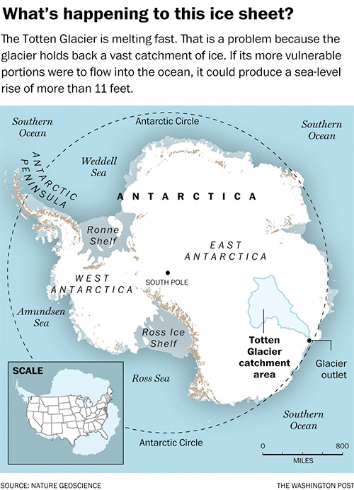
Latest News 30 September 2025, The Conversation: Air temperatures over Antarctica have soared 35ºC above average. What does this unusual event mean for Australia? Right now, cold air high above Antarctica is up to 35ºC warmer than normal. Normally, strong winds and the lack of sun would keep the temperature at around –55°C. But it’s risen sharply to around –20°C. The sudden heating began in early September and is still taking place. Three separate pulses of heat have each pushed temperatures up by 25ºC or more. Temperatures spiked and fell back and spiked again. It looks as if an unusual event known as sudden stratospheric warming is taking place – the unexpected warming of the stratosphere, 12 to 40 kilometres above ground. In the middle of an Antarctic winter, this atmospheric layer is normally exceptionally cold, averaging around –80°C. By the end of September it would be roughly –50ºC. This month, atmospheric waves carrying heat from the surface have pushed up into this layer. In the Northern Hemisphere, these events are very common, occurring once every two years. But in the south, sudden large-scale warming was long thought to be extremely rare. My research has shown they are more common than expected, if we group the very strong 2002 event with slightly weaker events such as in 2019 and 2024. Sudden warming may sound ominous. But weather is messy. Many factors play into what happens down where we live. Read more Here 13 June 2025, The Conversation: As Antarctic sea ice shrinks, iconic emperor penguins are in more peril than we thought. When winter comes to Antarctica, seals and Adélie penguins leave the freezing shores and head for the edge of the forming sea ice. But emperor penguins stay put. The existence of emperor penguins seems all but impossible. Their lives revolve around seasons, timing and access to “fast ice” – sea ice connected to the Antarctic coast. Here, the sea ice persists long enough into summer for the penguins to rear their chicks successfully. But climate change is upending the penguins’ carefully tuned biological cycles. The crucial sea ice they depend on is melting too early, plunging the chicks from some colonies into the sea before they are fully fledged. In the latest bad news for these penguins, research by the British Antarctic Survey examined satellite images from 2009 to 2024 to assess fast-ice conditions at 16 emperor penguin colonies south of South America. They noted an average 22% fall in numbers across these colonies. That translates to a decrease of 1.6% every year. This rate of loss is staggering. As the paper’s lead author Peter Fretwell told the ABC, the rate is about 50% worse than even the most pessimistic estimates. Read more here The Conversation, 5 August 2024: Antarctic heat, wild Australian winter: what’s happening to the weather and what it means for the rest of the year. Australia’s south and east have seen freezing temperatures and wild weather this winter. At the same time, the continent as a whole – and the globe – have continued to warm. What’s going on? As ever, it’s hard to pinpoint a single cause for weather events. But a key player is likely an event unfolding high above Antarctica, which itself may have been triggered by a heatwave at surface level on the frozen continent. Here’s what’s happening – and what it might mean for the rest of this year’s weather. When the stratosphere heats up Our story begins in the cold air over Antarctica. July temperatures in the stratosphere, the layer of air stretching between altitudes of around 10 and 50 kilometres, are typically around –80°C. The winds are also very strong, averaging about 300 kilometres per hour in winter. These cold, fast winds loop around above the pole in what is called the stratospheric polar vortex. Occasionally, persistent high air pressure in the lower atmosphere can influence large-scale waves that extend around the globe and up into the stratosphere. There they cause the strong winds to slow down, and the air high above the pole to become much warmer than normal. In extreme situations the stratospheric winds can completely break down, in what is called a “sudden stratospheric warming” event. These events occur every few years in the northern hemisphere, but only one has ever been observed in the south, in 2002 (though another almost happened in 2019). Read more here 26 March 2024, Carbon Brief: Antarctic sea ice ‘behaving strangely’ as Arctic reaches ‘below-average’ winter peak. Antarctic sea ice is “behaving strangely” and might have entered a “new regime”, the director of the US National Snow and Ice Data Centre (NSIDC) tells Carbon Brief. Following an all-time low maximum in September 2023, Antarctic sea ice has been tracking at near-record-low extent for the past six months. Last month, it hit its 2024 minimum extent, tying with 2022 for the second-lowest Antarctic minimum in the 46-year satellite record. Dr Mark Serreze, director of the NSIDC tells Carbon Brief that more warm ocean water is reaching the surface to melt ice and keep it from forming. He says that we “must wait and see” whether this is a “temporary effect” or whether the Antarctic has entered a “new regime”. Meanwhile, Arctic sea ice has reached its maximum extent for the year, peaking at 15.01m square kilometres (km2) on 14 March. The provisional data from the NSIDC shows that this year’s Arctic winter peak, despite favourable winds that encouraged sea ice formation, was 640,000km2 smaller than the 1981-2010 average maximum. This year’s maximum was the 14th lowest in the satellite record. “Overall, the road remains downhill for Arctic sea ice, but it is quite bumpy along the way,” another scientist tells Carbon Brief. This relatively high winter peak is “notable and a good reminder that we have to communicate and account for this type of weather variability when we talk about Arctic climate change”, he says. He adds that although the maximum is high compared to recent years, the ice is still “much thinner” than it was a few decades ago. The “wide coverage of this thinner ice” means total Arctic sea ice volume for the month of February was the third lowest on record. Record-breaking Antarctic extent Antarctic sea ice has been tracking at or near record-low levels for months. The Antarctic set a record-low maximum on 10 September 2023, with an extent of 16.96m km2. This was “the lowest sea ice maximum in the 1979 to 2023 sea ice record by a wide margin”, and one of the earliest, the NSIDC says. Antarctic conditions over 2023 were “truly exceptional” and “completely outside the bounds of normality”, one expert told Carbon Brief. As 2023 progressed, Antarctic sea ice melt was “slower than average”, the NSIDC says. The total decline in Antarctic sea ice extent through October was 903,000km2, while the October average was 985,000km2. Nevertheless, Antarctic sea ice extent continued to track at a record low. On 31 October 2023, Antarctic sea ice extent was still tracking at a record-low of 15.79m km2. This is 750,000km2 below the previous 31 October record low. The decline in Antarctic sea ice paused for a few days from 9 November, allowing sea ice extent to creep above the November 2016 value, the NSIDC says. This marked the first time that the daily 2023 Antarctic sea ice extent was not the lowest in the record since early May 2023. By the start of December, Antarctic sea ice extent was again at a record low, it notes. The Antarctic saw in the new year with a sea ice extent of 6.37m km2, marking the sixth-lowest New Year’s Day Antarctic sea ice extent on record, the NSIDC says. Ice melted rapidly throughout the month, and by the end of January, daily Antarctic sea ice extent reached 2.58m km2 – tying with 2017 for second lowest on record. Read more here 24 October 2023, Reuters: Meltdown of West Antarctic Ice Sheet unavoidable, study says. The West Antarctic Ice Sheet will continue to melt this century regardless of how much the world slashes planet-warming emissions, research from the British Antarctic Survey has found, locking in further sea level rise over the coming decades. The study, published in the journal Nature Climate Change on Monday, found no matter the degree of warming this century, the melting of the West Antarctic Ice Sheet will speed up as warmer water in the Amundsen Sea erodes ice shelves bordering the ocean. These ice shelves buttress ice further inland, acting as a cork in a bottle that stops their flow into the ocean. Even under the best-case scenario of 1.5 degrees Celsius (2.7 Fahrenheit) of warming above pre-industrial levels, ice would melt three times faster this century than it did last century. “Reducing emissions can help to prevent the worst-case scenario of melting, but beyond that mitigation has a negligible impact,” said lead author Kaitlin Naughten, an ocean-ice modeller at the British Antarctic Survey. “It appears we may have lost control”. The collapse of the West Antarctic Ice Sheet is one of nine global climate ‘tipping points’ scientists identified in 2009. The passing of these environmental red lines would be catastrophic for life on Earth. An international team of scientists said in 2022 we may already have passed the point of no return for the West Antarctic Ice Sheet at just 1.1 Celsius of warming above pre-industrial levels. If the ice sheet were to fully melt, average global sea levels would rise by more than a metre. Read more here 13 September 2023, The Conversation: Devastatingly low Antarctic sea ice may be the ‘new abnormal’, study warns. For most of us, Antarctic sea ice is an abstraction – something far away we may have seen on a documentary. But the radiant white sheets of ice floating on the seas around the snowy continent are a crucial component of Earth’s climate processes. Sea ice insulates the ocean, reflects heat, drives currents, supports ecosystems and protects ice shelves. It also has an annual seasonal cycle – some of the ice melts, then freezes again. Every year, the cycle of freeze and melt around Antarctica has been extremely reliable. Until recently. In a new study published today in Communications Earth & Environment, we have found a preliminary indication that Antarctic sea ice may have entered a new state of diminished coverage. A sudden, dramatic loss. For many years, while the Arctic lost sea ice, the Antarctic did not. Then, in the spring of 2016, Antarctic sea-ice coverage dropped dramatically. Over two years, the Antarctic lost as much sea ice as the Arctic had lost in three decades. Since then, Antarctic sea ice has been below average almost constantly. This past Southern Hemisphere summer, Antarctic sea ice was the lowest it has ever been, with dire consequences. In late 2022 we saw the heartbreaking loss of 10,000 emperor penguin chicks, when the sea ice they lived on melted before they had grown their waterproof feathers. On February 19 2023, Antarctic sea ice set a new record minimum of 1.77 million square kilometres, 36% below the 1979–2022 average for the summer minimum. Read more here End Latest News Antarctica’s glaciers crunch, grind and calve their way into the sea. Gargantuan towers of ice, the size of city blocks, glow in shades of pink, violet, and baby blue. Humpback whales gracefully loop through the frigid water in search of a meal of krill. Icebergs are home for 18-foot, 4.5-ton elephant seals which haul themselves out of the water and gather on icy banks while southern albatrosses soar overhead; royal penguins gather in a colony of thousands upon thousands of nesting birds and their fluffy, bewildered chicks. Source: Antarctic Waters – Heritage Expeditions Produced by James Muir. 30 September 2025, The Conversation: Air temper 1 August 2023, The Conversation: Deadly heatwaves, raging wildfires and record global temperatures are upon us. After a record high two years prior, the amount of sea ice fell dramatically at the end of 2016 to a record minimum in February 2017. This was followed by successive low years with the southern hemisphere summer record again being broken in February 2022 and most recently, a new lowest extent of 1.79 million square kilometres being recorded in 2023, a fall of nearly 10% from last year’s summer record. Read more here Antarctic alarm bells: observations reveal deep ocean currents are slowing earlier than predicted 26 May 2023, The Conversation: Antarctica sets the stage for the world’s greatest waterfall. The action takes place beneath the surface of the ocean. Here, trillions of tonnes of cold, dense, oxygen-rich water cascade off the continental shelf and sink to great depths. This Antarctic “bottom water” then spreads north along the sea floor in deep ocean currents, before slowly rising, thousands of kilometres away. In this way, Antarctica drives a global network of ocean currents called the “overturning circulation” that redistributes heat, carbon and nutrients around the globe. The overturning is crucial to keeping Earth’s climate stable. It’s also the main way oxygen reaches the deep ocean. But there are signs this circulation is slowing down and it’s happening decades earlier than predicted. This slowdown has the potential to disrupt the connection between the Antarctic coasts and the deep ocean, with profound consequences for Earth’s climate, sea level and marine life. Our new research, published today in the journal Nature Climate Change, uses real-world observations to decipher how and why the deep ocean around Antarctica has changed over the past three decades. Our measurements show the overturning circulation has slowed by almost a third (30%) and deep ocean oxygen levels are declining. This is happening even earlier than climate models predicted. Read more here How climate change will reshape the frozen continent 24 January 2019, ABC News, Antarctica’s winners and losers: How climate change will reshape the frozen continente rate of melting in Antarctica has almost tripled in the past five years, according to recent data. As the ice sheets retreat and seas remain ice-free for more of the year, some animals will reap the benefits, while others will suffer as their food and habitat disappears. Now scientists have attempted to quantify which animals will be the winners and losers as the frozen continent thaws. In research published in Frontiers in Marine Science today, scientists calculate the effects of pH, salinity, food availability, glacial retreat, sea ice loss, human impact and increased UV and wind on Antarctic animals in the near term for climate-driven habitat changes. The researchers calculated the net-benefit/impact of changes for each species using a simple, non-weighted scoring system. For instance, where temperature was calculated to benefit an animal, that species received 1 point. If diminished food availability was predicted, that species lost a point. Read more here IMAGE: Even if some animals benefit, the overall result will be less diversity. (Gary Dowse/Australian Antarctic Division) 28 May 2017, Climate News Network, Antarctica heights settle polar warming puzzle. Computer simulation shows that Antarctica is warming far slower than the Arctic region because of its much greater height. Scientists believe they have settled one of the great polar puzzles − why Antarctica is warming at a rate so much slower than the Arctic region. And the answer is a simple one: Antarctica is so much higher. To ram the point home, they used a computer simulation to hammer the entire southern continent until it was no more than a metre above sea level. At which point, in their simulation, warming at the South Pole became much more dramatic. The two poles are very different: the Arctic is an ocean almost entirely surrounded by land, while Antarctica is a vast continent entirely surrounded by frozen ocean. Landmass of ice As the north polar ocean ice melts, dark seas begin to absorb more radiation. In the southern hemisphere, the landmass of ice reflects radiation back into space to insulate the continent and keep its temperatures far below freezing. But the new study published in Earth System Dynamics journal shows that what makes the biggest difference is the elevation of the surface. Antarctica is not just an enormous continent: thanks to many millions of years of snowfall at very low temperatures, it is banked high with ancient ice. Its average elevation is 2,500 metres − far higher than the highest peaks in the UK, for example − and its highest mountain, Mount Vinson, reaches 4,892 metres, which is higher than any alpine peak in Europe. Evidence from the distant past and climate models both show that, in a warming world, the poles should warm faster than the rest of the planet. But while the Arctic is warming at twice the rate of the rest of the globe, change in Antarctica has been much more sluggish. Read More here Image: Torch Magazine via Flickr 21 February 2017, Climate Central, It’s summer in Antarctica, which has scientists scurrying around the seventh continent carrying out various research experiments. That includes monitoring the massive crack that has spread across the Larsen C ice shelf, located on the Antarctic Peninsula. On Tuesday, researchers with the British Antarctic Survey released new aerial footage showing the widening rift that threatens to tear the ice shelf asunder at any moment. The footage makes the immensity of the crack clear, as the yawning chasm stretches off into the horizon. The crack now stretches more than 100 miles in length. And at 1,500 feet across, you could lay the Empire State Building across the rift with a few feet to spare. The rift is expected to soon cleave a monster iceberg off the Larsen C ice shelf. Scientists estimate the iceberg could be up to 1,930 square miles in size, or roughly 10 percent of the whole ice shelf. That’s the equivalent of Delaware (or a quarter the size of Wales if you prefer Commonwealth measurements). Read More here 15 February 2017, Climate Central, The growing crack in the Larsen C ice shelf is the most dramatic example of change in Antarctica right now. But it isn’t the continent’s only frozen feature changing in a warming world. Ice around the continent is disappearing as the air and water heat up and the less dramatic breakdowns are just as important to understanding the fate of the ice and the world’s coastal areas. The Pine Island Glacier on the coast of West Antarctica is a case in point. A massive iceberg roughly 225 square miles in size — or in more familiar terms, 10 times the size of Manhattan — broke off in July 2015. Scientists subsequently spotted cracks in the glacier on a November 2016 flyover. And in January, another iceberg cleaved off the glacier. Satellite imagery captured the most recent calving event, which Ohio State glaciologist Ian Howat said “ is the equivalent of an ‘aftershock’” following the July 2015 event. The iceberg was roughly “only” the size of Manhattan, underscoring just how dramatic the other breakups have been. Read More here But this year, a big spring meltdown in October and November suddenly reversed that trend and has led to continued record low sea ice levels as the summer melt season progressed. On Monday, Antarctic sea ice dropped to an all-time record low, beating out 1997. Sea ice has been particularly low in the Amundsen Sea region of Western Antarctica, thanks to unusually high temperatures there. But it’s not clear what is ultimately driving this dramatic reversal in Antarctic sea ice, or whether it will be temporary or marks a longer-term shift. Read More here 20 October 2016, Climate Home, Antartica’s great ice shelves project out over the ocean from the fringes of the land. They are in a state of rapid decline, losing a total of 310 cubic km of ice every year. Once a shelf becomes too thin to support its own weight, it collapses in dramatic style, as was witnessed by satellites when the 3,250 sq km Larsen B ice shelf disintegrated within a few months at the beginning of 2002. Source: Climate Home NASA 6 November 2015, Study: Mass gains of Antarctic ice sheet greater than losses NOTE: The findings reported here conflict with over a decade of other measurements, including previous NASA studies. However, challenges to existing findings are an integral part of the scientific process and can help clarify and advance understanding. Additional scrutiny and follow-up research will be required before this study can be reconciled with the preponderance of evidence supporting the widely accepted model of a shrinking Antarctic ice sheet. A new NASA study says that an increase in Antarctic snow accumulation that began 10,000 years ago is currently adding enough ice to the continent to outweigh the increased losses from its thinning glaciers. The research challenges the conclusions of other studies, including the Intergovernmental Panel on Climate Change’s (IPCC) 2013 report, which says that Antarctica is overall losing land ice. According to the new analysis of satellite data, the Antarctic ice sheet showed a net gain of 112 billion tons of ice a year from 1992 to 2001. That net gain slowed to 82 billion tons of ice per year between 2003 and 2008. Read More here NASA 19 October 2015: The growth of Antarctic sea ice was erratic this year: sea ice was at much higher than normal levels throughout much of the first half of 2015 until, in mid-July, it flattened out and even went below normal levels in mid-August. The sea ice cover recovered partially in September, but still this year’s maximum extent is 513,00 square miles (1.33 million square kilometers) below the record maximum extent, which was set in 2014. Scientists believe this year’s strong El Niño event, a natural phenomenon that warms the surface waters of the eastern equatorial Pacific Ocean, had an impact on the behavior of the sea ice cover around Antarctica. El Niño causes higher sea level pressure, warmer air temperature and warmer sea surface temperature in the Amundsen, Bellingshausen and Weddell seas in west Antarctica that affect the sea ice distribution. “After three record high extent years, this year marks a return toward normalcy for Antarctic sea ice,” said Walt Meier, a sea ice scientist at NASA’s Goddard Space Flight Center in Greenbelt, Maryland. “There may be more high years in the future because of the large year-to-year variation in Antarctic extent, but such extremes are not near as substantial as in the Arctic, where the declining trend towards a new normal is continuing.” This year’s maximum extent occurred fairly late: the mean date of the Antarctic maximum is Sept. 23 for 1981-2010. Read More here Reporting: 8 December 2015, Science Daily, Hot rock and ice: Volcanic chain underlies Antarctica The topography of West Antarctica below the ice sheet as viewed from above, looking toward the Antarctic Peninsula. Much of West Antarctica is a basin that lies below sea level (blue), although it is currently filled with ice, not water. West Antarctica was stretched and thinned as it moved away from East Antarctica, forming one of the world’s largest continental rift systems. Credit: Bedrock Consortium Planetary scientists would be thrilled if they could peel Earth like an orange and look at what lies beneath the thin crust. We live on the planet’s cold surface, but Earth is a solid body and the surface is continually deformed, split, wrinkled and ruptured by the roiling of warmer layers beneath it. The contrast between the surface and the depth is nowhere starker — or more important — than in Antarctica. What is causing the mysterious line of volcanoes that emerge from the ice sheet there, and what does it mean for the future of the ice? “Our understanding of what’s going on is really hampered because we can’t see the geology,” said Andrew Lloyd, a graduate student in earth and planetary sciences in Arts & Sciences at Washington University in St. Louis. “We have to turn to geophysical methods, such as seismology, to learn more,” he said. Lloyd helped deploy research seismometers across the West Antarctic Rift System and Marie Byrd Land in the austral summer of 2009-10. He then returned in late 2011 and snowmobiled more than 1,000 miles, living in a Scott tent, to recover the precious data. The recordings the instruments made of the reverberations of distant earthquakes from January 2010 to January 2012 were used to create maps of seismic velocities beneath the rift valley. An analysis of the maps was published online in the Journal of Geophysical Research: Solid Earth. This is the first time seismologists have been able to deploy instruments rugged enough to survive a winter in this part of the frozen continent, and so this is the first detailed look at Earth beneath this region. Not surprisingly, the maps show a giant blob of superheated rock about 60 miles beneath Mount Sidley, the last of a chain of volcanic mountains in Marie Byrd Land at one end of the transect. More surprisingly, they reveal hot rock beneath the Bentley Subglacial Trench, a deep basin at the other end of the transect. The Bentley Subglacial Trench is part of the West Antarctic Rift System and hot rock beneath the region indicates that this part of the rift system was active quite recently. Read More here Reporting: Scientists confirm that East Antarctica’s biggest glacier is melting from below By Chris Mooney October 26 2015 (Washington Post) Totten Glacier’s ice shelf edge. (Jamin Greenbaum) Earlier this year, we learned some worrisome climate news. Although Antarctic scientists have been most concerned about loss of ice in the western part of Antarctica, a study in Nature Geoscience suggested a vulnerability in the much larger ice sheet of East Antarctica, as well. East Antarctica’s enormous Totten Glacier, you see, has a key similarity with the glaciers of West Antarctica — namely, it is rooted deep below sea level. This means that it is potentially exposed to warm ocean waters, and the study in March uncovered a deep and 5-kilometer wide subsea valley beneath the glacier’s oceanfront ice shelf that, the authors said, could be a route for warm offshore water to reach its base. This might explain why the glacier has been observed to be thinning and lowering, or losing elevation, over time, they noted. Located along East Antarctica’s Sabrina Coast, Totten glacier is the ice sheet’s largest. It holds back 3.9 meters of potential sea level rise, or over 12 feet, and connects with the very deep and vast Aurora Subglacial Basin, which is also rooted well below sea level. So the results were treated as being of enormous consequence. But they’re not the end of the story, as there is vastly more to learn about Totten glacier. A new study out in Geophysical Research Letters reaffirms some of these core concerns about Totten’s melt — while also appearing to partly alleviate others. Xin Li, a researcher at the University of California, Irvine, worked with a team from her institution and NASA’s Jet Propulsion Laboratory to examine Totten using satellite imagery and aircraft data. The researchers documented for the first time just how much the glacier’s “grounding line” — the critical underwater area where ice, bedrock and the ocean meet — has been retreating inland over the years. The answer is quite a bit. The research found that between 1996 and 2013 Totten’s grounding line retreated as much as 3 kilometers in some places. That’s fast, but it’s not nearly so fast as what has been happening in West Antarctica, where the retreat in some areas has been as much as one to two kilometers per year. “This boundary is very important because that’s where the ice detaches from the bed and becomes afloat and frictionless,” says Li of the grounding line. So any change here is not good news. The researchers were only able to get data for 20 percent of the vast Totten glacier’s grounding line, but this region accounted for 70 percent of the glacier’s current ice loss into the ocean, and for its fastest thinning. A sigh of relief about Totten? A key question thus becomes whether the grounding line in this area could speed up its retreat and in particular, whether a “marine ice sheet instability,” which is thought to exist in West Antarctica, might also exist here. Such an instability is caused by the presence of a “retrograde” or downward-sloping seabed beneath the glacier, which means that warm water can continually get beneath the ice sheet as the grounding line retreats further and further downhill. The answer, the new study suggests, is no. “Immediately upstream of the grounding line there is a 7 kilometer long region — we call it an ice plain because the slopes are really flat, and for this part of the glacier, it could retreat very fast, in a couple of decades or so,” says Li. After that, though, the elevation actually rises for 40 kilometers, and so the retreat would not happen as quickly. “The bedrock topography at the end of the present Totten fjord (beneath the floating thick ice at the glacier front) is such that retreat is likely to proceed rapidly but then slow down,” observes Ted Scambos, lead scientist at the National Snow and Ice Data Center, who reviewed the new study for the Post. “There will be a glacier acceleration and thinning associated with the first retreat into a deep area but then some slowing.” “This is an area harder to destabilize dramatically than in Thwaites area” of West Antarctica, adds Penn State University glaciologist Richard Alley, commenting on the new study. But, he continues, “warming waters can influence this area and access a lot of ice leading to long-term large sea-level rise.” The new study, however, was not able to confirm or refute the existence of the canyon from the earlier paper in Nature Geoscience. There was no data available for the relevant area on the eastern side of the glacier — so this remains a possible route for how warm water may be reaching the glacier’s grounding line. What’s the bigger worry — Totten or Thwaites? A clear subtext of the new research is that the Thwaites glacier in West Antarctica is a bigger sea level threat than Totten — at least in the short term. But not everyone is so sure that the new research, in its delineation of what the bedrock is like near one key part of the Totten grounding line, does much to lessen concern about the region and its potential for eventually causing large sea level rise. Totten glacier “is super sensitive to that geometry, but it’s also super sensitive to the reorganization of the ocean, and how much heat is delivered,” says Don Blankenship, one of the authors of the Nature Geoscience study and a geoscientist at the University of Texas at Austin. Earlier this year, the Australian Antarctic Division reported ship measurements suggesting that warm ocean water is indeed reaching Totten glacier. In other words, Blankenship agrees with Li that the bedrock topography could temporarily slow down Totten’s retreat. But he thinks the warm ocean is more than powerful enough to overcome such a temporary hindrance over time – and after that, he says, the bedrock slopes down into the deep Aurora Subglacial Basin. Blankenship’s UT Austin colleagues and co-authors Duncan Young and Jamin Greenbaum, meanwhile, have discovered what they say is smaller region of potential marine ice sheet instability near the ocean trench. The grounding line in this area was not mapped in the new study because of a lack of data. Finally, they point to recent research suggesting new mechanisms that can destabilize truly gigantic and mostly submerged glaciers, like Totten, which are rooted well over 1,000 meters below sea level but also have ice extending over 100 meters into the air above sea level. If these glaciers lose their stabilizing ice shelves, the research suggests, then “ice cliff failure” will occur whenever there is a sheer ice face more than 100 meters high above the sea level. Therefore, these researchers say they are still looking at Totten glacier as a potential key to solving one of the most important mysteries in climate research: In past eras of Earth’s history that weren’t all that much warmer than today, scientists believe seas were much, much higher – so much so that not even a collapse of West Antarctica, alone, could account for it. Thus, they’re busy looking for the missing ice – or, the missing ocean water – that will balance these past sea level budgets. And they think Totten and the Aurora basin could be the place that it came from. Clearly, more data gathering will be very important — and will contribute to a continuing reassessment of the long-term vulnerability of East Antarctica, and especially this region. As Tas van Ommen, a senior scientist with the Australia Antarctic Division and also one of the authors of the Nature Geoscience paper, recently wrote: Previously we thought that, aside from a poorly mapped valley far inland of Casey known as Aurora Basin, most of the ice was resting on bedrock hills and mountains above sea level. It turns out that Aurora Basin is very deep and much larger than we thought. More seriously, the basin is connected to the coast by terrain that is extensively below sea level. This makes it much more like West Antarctica, where there is concern that gradual, but irreversible ice loss is underway. The prospect that such a pattern could also impact East Antarctica is a new one, and suggests that changes to the Totten Glacier might be the first stages of such accelerating loss in East Antarctica. Thus, the new research on Totten glacier, in the end, probably has two separate, important messages. First, it reemphasizes that Thwaites glacier, of West Antarctica, is likely the number one place that we should be worried about potentially delivering a lot of sea level rise on a time scale relevant to the people living today, and their children and grandchildren. That’s why Antarctic scientists are clamoring to do vastly more research there — immediately.But beyond Thwaites, there’s the second message. Other parts of Antarctica are also rooted underwater, and therefore vulnerable to warming oceans and recent changes in ocean currents. In the short term, due to their particular configurations, they may be more stable. But in the long term, it’s pretty simple: Heat melts ice. Reporting: Scientists declare an ‘urgent’ mission – study West Antarctica, and fast By Chris Mooney September 29 2015 (Washington Post) Scientists who have been raising alarms about the endangered ice sheet of West Antarctica say they’ve identified a key glacier that could pose the single most immediate threat to the world’s coastlines — and are pushing for an urgent new effort to study it. The glacier is not one that most people will have even heard of — Thwaites Glacier along the Amundsen Sea. It’s a monstrous body that is bigger than Pennsylvania and has discharged over 100 billion tons of ice each year in recent years. The glacier is both vast and vulnerable, because its ocean base is exposed to warm water and because of an unusual set of geographic circumstances that mean that if it starts collapsing, there may be no end to the process. But it’s also difficult to study because of its location — not near any U.S. research base, and in an area known for treacherous weather. As a result, the researchers are also calling for more support from the federal government to make studying West Antarctica’s glaciers, and Thwaites in particular, a top priority. “In some scenarios, the next 50 years or 100 years could see, you could begin to see very rapid ice loss from central West Antarctica. It’s the wild card,” said Ted Scambos, the lead scientist at the National Snow and Ice Data Center who chaired a meeting earlier this month of West Antarctic scientists outside Loveland, Colorado. Thwaites, says Scambos, has “much more upward potential than we realized.” “It is hard to find tipping points in physical systems likely to be activated in the near future, with the possible exception of Thwaites,” Richard Alley, a glaciologist at Penn State University, said at the meeting. The scientists are backed by a just released report by the U.S. National Academy of Sciences, which concluded that the National Science Foundation – which runs U.S. Antarctic programs – should make research on Antarctica’s sea level implications its top priority, with a particular emphasis on West Antarctica. That’s because much of its ice is below sea level and thus “vulnerable to a runaway collapse process known as marine ice sheet instability.” “There is an urgent need to understand this process in order to better assess how future sea level rise from ice sheets might proceed,” the report stated. “This was our number one priority, across all disciplines,” said Robin Bell, a senior scientist at Columbia University’s Lamont-Doherty Earth Observatory who co-chaired the National Academy of Sciences panel, at the Colorado meeting. Bell said that the consensus on this point emerged from the community of Antarctic researchers themselves, whose views were extensively solicited in forming the document. The National Science Foundation has not yet said how it will respond to this unusual show of unanimity among Antarctic scientists. “NSF would like to see a wide distribution of the report’s recommendations in order to prompt a discussion in the research community and among other agencies with a stake in Antarctic research,” agency spokesman Peter West said in a statement. “Such an approach would help the NSF shape its response to the recommendations for the future of the U.S Antarctic Program, which it manages.” It’s not just U.S. scientific authorities worrying about Thwaites. In Colorado, representatives of the British Antarctic Survey, which along with the United States is a leader of Antarctic research, sounded a similar note. David Vaughan, the survey’s director of science, said he believed a central research goal should be “looking at the longer term commitment to sea level rise that is inherent in the West Antarctic ice sheet, with a geographic focus on Thwaites Glacier, what we already now agree is potentially the most vulnerable part.” A worry for decades. Concerns about West Antarctica aren’t new. In a landmark paper published in 1978, the Ohio State University glaciologist John Mercer singled out the region as posing a “threat of disaster” because the majority of the vast ice sheet is rooted far below sea level. Were it to melt due to global warming, “major dislocations in coastal cities, and submergence of low-lying areas such as much of Florida and the Netherlands, lies ahead,” Mercer wrote. But it took much longer for scientists to convince themselves that Mercer might be right — by studying West Antarctica to identify its most vulnerable regions, and then by using satellites and other means of remote observation to actually document their changes. “There has been a pendulum in this community in the last 20 years, from, ‘we’re sure the West Antarctic Ice Sheet is going to collapse,’ to ‘actually we’re not,’ to ‘oh yes we are,’ to ‘oh, it’s happening now,’” says Eric Steig, a University of Washington glaciologist who spoke at the meeting on how to find cores of ancient ice that might prove whether West Antarctica collapsed during a past warm period, some 120,000 years ago. “I think that many of the ideas that people came up with for why it won’t collapse have been disproven,” Steig says – although he emphasizes that there is still a great deal of scientific uncertainty about the matter. More and more, the vulnerable point appears to be Thwaites Glacier on the coast of the Amundsen Sea — a remote and difficult to reach part of West Antarctica that is not particularly close to any of the U.S.’s three Antarctic research stations. The Amundsen Sea’s glaciers are roughly midway along the Antarctic coast between the U.S.’s Palmer Station, near the tip of the Antarctic peninsula, and McMurdo Station, near the Ross Ice Shelf – representing a considerable trip from either point. The total distance between the peninsula and McMurdo is a staggering 4,000 kilometers, or nearly 2,500 miles. The Amundsen region was once considered to have “such terrible weather conditions that field operations would be near to impossible,” as the British Antarctic Survey’s Vaughan put it in a 2006 paper. “The number of people who have stood on Thwaites Glacier, you can count on the fingers of a couple of hands,” says Sridhar Anandakrishnan, a glaciologist at Penn State University who has actually been to Thwaites on several research expeditions, and says the glacier has “the highest probability of having a huge change on sea level.” But the location is not a problem for satellites, which have recently led to the conclusion that glaciers throughout the Amundsen coast – including Thwaites’ partners Pine Island, Haynes, Smith and Kohler — have been retreating rapidly at their subsea bases and losing ice. The cause is not warming air temperatures, as Mercer had suspected, but rather warmer ocean waters reaching the base of the coastal glaciers – which are rooted hundreds of meters below sea level – and melting them from below. This does appear to be caused by climate change, albeit in a complex way, explains Robert Bindschadler, a NASA researcher who headed the annual meeting of West Antarctic scientists for 20 years and has an Antarctic glacier named after him. Because the tropics and subtropics have been warming faster than the Antarctic, Bindschadler explains, the greater temperature differential from equator to pole has driven fiercer winds around the Antarctic continent. And those, in turn, have pushed so-called circumpolar deep water, which is the warm middle ocean layer in this region, onto continental shelves where it can reach the base of glaciers. “There’s so much heat in that layer, it could wipe out the entire ice sheet,” says Bindschadler — even though the water is just a few degrees above freezing. The water is also quite salty and dense, so it travels to the lowest accessible point of the submerged glacier — the so-called “grounding line,” where the glacier front touches the seafloor, hundreds of meters below the sea surface. And then, it starts a process of rapid melting. Last year, a pair of blockbuster research papers found not only that the Amundsen Sea’s glaciers were experiencing rapid grounding line retreat, but suggested that there may be no apparent end to the process. That’s because the glaciers lie on a “retrograde” bed, where the ground beneath the glacier slopes downhill rapidly as you move further inland – for Thwaites, over a kilometer in some regions lies below sea level. “It’s just a soup bowl. It just drops off,” says Anandakrishnan. Thus, the thinking goes, the warm water can continually chase the retreating grounding line downhill. That’s true in much of the region, but what sets Thwaites apart from the other Amundsen Sea glaciers — including its fast-moving neighbor, Pine Island glacier — is its gigantic size. Its oceanfront expanse is 120 kilometers wide, where Pine Island’s is only 30 kilometers. Also unlike Pine Island, Thwaites is “not confined in a valley, hence with the potential for a much larger increase in ice flux if the flow acceleration continues at the same pace,” as a recent study put it. Thwaites is also well over 2 kilometers thick in places. And while it is not synonymous with West Antarctica as a whole – which has been estimated to contain 3.3 meters or just under 11 feet of total potential sea level rise – it could blaze the path toward a larger retreat. “It has the biggest basin, it would kind of eat out the heart of the West Antarctic Ice Sheet if it started to retreat rapidly,” says Bindschadler. The crucial question of timing. But how soon could that happen? Last year, Ian Joughin, a respected glaciologist at the University of Washington, published a paper in Science on Thwaites with two colleagues, in which he predicted that “a full-scale collapse of this sector may be inevitable,” but added that his model “leaves large uncertainty in the timing.” He put the range between 200 and 900 years for the “onset” of rapid collapse. But some scientists now wonder if an important part of the change could happen still faster. One problem is that in addition to last year’s research documenting rapid grounding line retreat in the Thwaites region, modeling work published earlier this year highlighted two more processes involved in glacial collapse, both of which could accelerate its speed. One of them is the concept of “ice cliff failure,” which suggests that a sheer wall of ice more than 100 meters high (above water) can’t hold. Ice, after all, is not an extremely strong or durable material. “The maximum ice cliff is 100 meters, beyond that the yield stress of ice will just disintegrate,” says David Pollard, a glaciologist at Penn State University who led the new research. The fear is that as Thwaites (or potentially some other glaciers) become destabilized, it may produce ice cliffs higher than 100 meters which will then collapse. Granted, scientists are not saying yet that this will happen on a time scale that will immediately affect people alive today, or their children and grandchildren – just that they fear it could. Contending with a very hard phenomenon to study, they’re still trying to understand what’s truly possible. The suggestion of mechanisms like cliff collapse “create a need to understand the ice-ocean processes in that area of Antarctica now, and also to understand the bedrock topography, in more detail — now,” says Scambos. That means a great deal more research and direct measurements in this extremely remote environment. It isn’t research on the moon or at the ocean’s greatest depths, but in terms of work on or near the surface of Earth, it’s about as tough as it gets. To understand the difficulty of the scientific task, consider this — one key problem will be figuring out exactly what is going on at the ground level beneath over a mile of ice. A key unknown involves precisely what kind of terrain the base of Thwaites glacier rests upon, and what it is composed of – which will affect just how much resistance there is to the glacier’s movement. “Whether that base is slippery, or not slippery, makes all the difference in whether Thwaites glacier disappears in 100 years or 1000 years,” says Anandakrishnan. Such research can be conducted through seismic measurements atop the glacier. Even more complicated, though, is determining what’s happening at the Thwaites glacier’s dynamic oceanfront and ice shelf, where there is continual ice flow into the sea and large crevasses. A call for more resources: The entire situation is further complicated by the limited resources available for Antarctic science. The National Academies report called for greater investment in logistical support for scientists, including all-weather aircraft and heavy icebreakers, noting that the research must be conducted in “a notoriously challenging area to work in, with difficult weather conditions often limiting flight operations.” “This really is the logistics we need in order to be able to answer those questions about the West Antarctic ice sheet,” said Columbia’s Bell, who co-chaired the report. Meanwhile, at the Colorado meeting, the British Antarctic Survey’s David Vaughan suggested the need for a similar British research investment in studying the Amundsen Sea and Thwaites — a follow up to extensive work the survey just helped to conduct on nearby Pine Island glacier. “We would like a very high resolution sub-glacial topography, to see if there’s any major points where this grounding line retreat would hang up for a couple of decades, enough to make a difference,” Vaughn said. Yet another aspect of the required research, meanwhile, will be trying to discover whether Thwaites and other parts of West Antarctica vanished in past warm periods of Earth’s history — as researchers suspect — which would give a further hint about their vulnerability. That requires more “paleo-climate” research, in which scientists drill huge cores of ancient ice and collect samples of sediments or date the ages of rocks to try to determine what happened thousands or even hundreds of thousands of years ago. “There is a clear signal that could be found in ice cores, but we haven’t drilled in the right place,” says the University of Washington’s Steig. So in sum — scientists are not yet convinced that a disaster is emerging at Thwaites glacier. Further inquiries could still demonstrate new reasons that the glacier might be more stable than some fear, particularly if there are aspects of the topography beneath Thwaites that would in some way slow its retreat. The researchers aren’t stating outright that the glacier poses a threat this century — rather, they want to find out if it does. “I’ve been working on this for 38 years,” says Penn State’s Richard Alley, one of the most outspoken of the WAIS scientists. “And I always believed that we would learn, and we would take useful information and we would give it to policymakers and they would use it. And that we’d do this in time to be really useful.” Now, Alley says he just hopes that’s still the case. “It may be that West Antarctica is still going to hang around a while, but the impetus to understand better I think has gotten way stronger.” It’s nearly 30 years since the discovery of the Ozone Hole drew world attention to the impact of human activity on the global environment.Air temperatures over Antarctica have soared 35ºC above average. What does this unusual event mean for Australia?
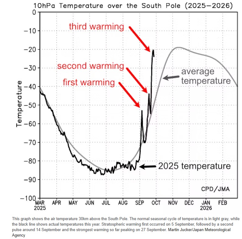 atures over Antarctica have soared 35ºC above average. What does this unusual event mean for Australia? Right now, cold air high above Antarctica is up to 35ºC warmer than normal. Normally, strong winds and the lack of sun would keep the temperature at around –55°C. But it’s risen sharply to around –20°C. The sudden heating began in early September and is still taking place. Three separate pulses of heat have each pushed temperatures up by 25ºC or more. Temperatures spiked and fell back and spiked again. It looks as if an unusual event known as sudden stratospheric warming is taking place – the unexpected warming of the stratosphere, 12 to 40 kilometres above ground. In the middle of an Antarctic winter, this atmospheric layer is normally exceptionally cold, averaging around –80°C. By the end of September it would be roughly –50ºC. This month, atmospheric waves carrying heat from the surface have pushed up into this layer. In the Northern Hemisphere, these events are very common, occurring once every two years. But in the south, sudden large-scale warming was long thought to be extremely rare. My research has shown they are more common than expected, if we group the very strong 2002 event with slightly weaker events such as in 2019 and 2024. Sudden warming may sound ominous. But weather is messy. Many factors play into what happens down where we live. Read more Here
Devastatingly low Antarctic sea ice may be the ‘new abnormal’
 13 September 2023, The Conversation: Devastatingly low Antarctic sea ice may be the ‘new abnormal’, study warns. For most of us, Antarctic sea ice is an abstraction – something far away we may have seen on a documentary. But the radiant white sheets of ice floating on the seas around the snowy continent are a crucial component of Earth’s climate processes. Sea ice insulates the ocean, reflects heat, drives currents, supports ecosystems and protects ice shelves. It also has an annual seasonal cycle – some of the ice melts, then freezes again. Every year, the cycle of freeze and melt around Antarctica has been extremely reliable. Until recently. In a new study published today in Communications Earth & Environment, we have found a preliminary indication that Antarctic sea ice may have entered a new state of diminished coverage. A sudden, dramatic loss. For many years, while the Arctic lost sea ice, the Antarctic did not. Then, in the spring of 2016, Antarctic sea-ice coverage dropped dramatically. Over two years, the Antarctic lost as much sea ice as the Arctic had lost in three decades. Since then, Antarctic sea ice has been below average almost constantly. This past Southern Hemisphere summer, Antarctic sea ice was the lowest it has ever been, with dire consequences. In late 2022 we saw the heartbreaking loss of 10,000 emperor penguin chicks, when the sea ice they lived on melted before they had grown their waterproof feathers. On February 19 2023, Antarctic sea ice set a new record minimum of 1.77 million square kilometres, 36% below the 1979–2022 average for the summer minimum. Read more here
Antarctica is missing a chunk of sea ice bigger than Greenland – what’s going on?
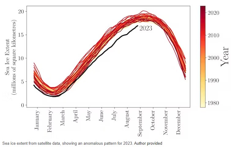
 But far from the flames, at the southernmost tip of the planet, something just as shocking is unfolding. It’s Antarctic winter, a time when the area of floating sea ice around the continent should be rapidly expanding. This year though, the freeze-up has been happening in slow motion. After reaching a record low minimum extent this summer there is now an area of open ocean bigger than Greenland. If the “missing” sea ice were a country, it’d be the tenth largest in the world. …
A puzzle solved: Why Antarctica warming slower than Arctic
 13 February 2017, Climate Central, Arctic temperatures have finally started to cool off after yet another winter heat wave stunted sea ice growth over the weekend. The repeated bouts of warm weather this season have stunned even seasoned polar researchers, and could push the Arctic to a record low winter peak for the third year in a row. Meanwhile, Antarctic sea ice set an all-time record low on Monday in a dramatic reversal from the record highs of recent years. Sea ice at both poles has been expected to decline as the planet heats up from the buildup of greenhouse gases in the atmosphere. That trend is clear in the Arctic, where summer sea ice now covers half the area it did in the early 1970s. Sea ice levels in Antarctica are much more variable, though, and scientists are still unraveling the processes that affect it from year to year…… Antarctic Reversal Antarctic sea ice is an altogether different beast. Instead of an ice-filled ocean surrounded by land, it is a continent surrounded by ocean that sees much more variability in sea ice levels from year to year for reasons that aren’t fully understood. For several of the past few years, the sea ice that fringed Antarctic reached record highs. That growth of sea ice could have potentially been caused by the influx of freshwater as glaciers on land melted, or from changes in the winds that whip around the continent (changes that could be linked to warming or the loss of ozone high in the atmosphere).
View of the Thwaites Glacier survey area showing the patchy layer of high clouds. Credit: NASA/Michael Studinger.
- The discovery of the Ozone Hole was first announced in a paper by British Antarctic Survey’s Joe Farman, Brian Gardiner and Jonathan Shanklin (pictured at top), which appeared in the journal Nature in May 1985.
- Ozone in the atmosphere is measured using the Dobson Spectrophotometer – equipment designed in the 1920s, but still the world standard. Ozone is measured in Dobson Units, DU and a typical measurement is about 300 DU.
- An ozone hole is defined as an area of the atmosphere having ozone values less than 220 DU.
- If you took all the ozone in a vertical column above the instrument and brought it down to sea level it would form a layer just three millimetres thick.
- Major volcanic eruptions, such as the 1991 eruption of Mount Pinatubo in the Philippines may put material which enhances ozone depletion into the stratosphere.
- Scientists working in Antarctica wear high-factor sunscreen to avoid sunburn when working outside, especially as sunlight is also reflected from the snow surface. You can get burnt in as little as five minutes without it!
Source: British Antarctic Survey
Understanding the Ozone Layer of Antarctica
How advances of the Montreal Protocol is significant for UNFCCC outcomes
 It’s hard to imagine the rhetoric soaring to greater heights.“A great signal for Paris”,”a much needed shot in the arm for climate action”, “provide an example of successful international cooperation”, “provide critical momentum for the climate negotiations”, “a strong signal to the UNFCCC to adopt a robust agreement at COP 21”, “boosting global cooperation ahead of Paris to benefit the planet”…Expectations were almost palpable.“A singular opportunity for countries to take action on climate”,”would set the stage for an ambitious and durable global climate agreement”, “lay the foundation for a global agreement in Paris that will protect generations to come”, “demonstrate that governments around the world have the political will to take bold action to avert a climate catastrophe”, “potentially catalyse far-reaching action at Paris”…
Stirring stuff indeed, but who’d have guessed what all the fuss was about? You’d be forgiven for missing the muted clamour anticipating a long overdue agreement on the need to respond to the science calling for international action on the world’s most powerful and rapidly growing greenhouse gases. In a much anticipated gathering of the global community of nations in Dubai over the past week, intense negotiations have been taking place. The ultimate goal of the talks, which began in 2008, is to amend the Montreal Protocol to formally address the need to address the alarmingly rapid rise of the hydrofluorocarbons, or HFCs, highly potent greenhouse gases used across the refrigeration and air conditioning industries.
A recent NASA study reported to the meeting also confirmed that contrary to previous understanding HFCs do have a small yet significant effect on ozone depletion, a point poignantly underscored by the appearance of the third largest Ozone hole this year. The numbers are by any measure impressive. At stake is the opportunity to preserve the 135 billion tonnes CO2-e inadvertent climate benefits of phasing out the ozone depleting (and incredibly powerful greenhouse gases) CFCs, to slow the 10-15% annual increases in HFC emissions, to reduce emissions by 100-200 billion tonnes CO2-e by 2050, and to limit the increase in global temperature by 0.5 degrees C by 2100. Failure to act on HFCs would see them contributing up to 29% of global CO2 emissions by 2050.
Progress at the unprecedentedly resumed 36th Open Ended Working Group (from stalemated #OEWG36 meetings in Paris in July) in Dubai prior to the MOP gave rise to initial hopes that prospects of reaching agreement on some combination of the four HFC amendment proposals on the table might be reached. Formation of a formal “contact group” to consider the proposals and resolve the many challenges and solutions, timing, flexibility, feasibility and financing issues has been a major stumbling block, previously surmounted by “informal discussions”. Establishment of this contact group in order to progress the discussions was a priority objective of Parties supporting the HFC amendment proposals, and removes a critical procedural blockage. Along with China, Australia was privileged to serve as a Co-Chair of this long awaited group.
Delivering a moral imperative to the UNFCCC in Paris to follow the example set in Dubai was tantalisingly within reach. However formidable obstacles and tight timeframes for negotiations to take place conspired against progress being made, in spite of the presence of many senior figures. Pessimistic rumblings that any agreement would be able to be reached were heard during the week, and it was always inevitable that a decision would only be reached long after the scheduled closing time. Whilst the genuine virtues of the Montreal Protocol as the world’s most successful Multilateral Environmental Agreement are frequently and legitimately proclaimed at these meetings, the deeply regrettable deafness of the Parties in the 1990’s to concerns raised by Greenpeace (among others) about the climate impacts of HFCs is rarely acknowledged.
In the rush to phase out CFCs while limiting the financial impacts on the balance sheets of chemical companies, it is unfortunate that the solutions then presented by climate friendly natural refrigerants were overlooked. Wiser allocation of the resources of the Montreal Protocol twenty years ago to support research and commercialisation of ammonia, carbon dioxide, hydrocarbons, air and water (the “friendly five”) could have averted much of the HFC (and HCFC) problem we currently face. Fortunately these future proof, climate safe solutions are now available, and the pace of innovation and scale of commercialisation are impressive. However gaining acceptance of these realities among the parties who continue to obstruct agreement on the HFC amendment appears to be a long way off. By adopting a significantly more ambitious goal to comprehensively act on phasing out HFCs in Australia, there is much our newly innovative and agile Government could be doing to take responsibility for reducing our HFC emissions, setting an example to the world, and fostering the ability of Australian industry to meet the enormous global demand for climate friendly cooling technologies.
Much talk in the Dubai meeting Plenary and HFCs Management Contact Group has focussed on strategies to keep the amendment proposals alive, and to establish a “Dubai Roadmap” to achieve real progress in 2016. While a substantial majority of the 197 countries present are supportive of adopting an amendment, a small yet persistent group led by Saudi Arabia have continued to obstruct negotiations. Ostensibly their opposition is due mainly to concerns about the availability of climate friendly solutions suited to high ambient temperatures, yet the strategy of holding out in exchange for concessions at the Paris talks is only thinly disguised. Perhaps the Dubai MOP is best summed up by a delegate reported as remarking in the corridors “If the camel once gets his nose in the tent, the body will soon follow”. It took until the wee small hours of Friday morning for the Contact Group to deliver an agreed text to the Plenary that sets a clear path for decisive progress, and sets up an extraordinary meeting to achieve this next year. What is important is the process has moved a large step forward, and the inexorable momentum to secure an amendment in 2016 to begin to stem the flow of HFCs remains strong.
In common with efforts at the UNFCCC talks, what the efforts under the Montreal Protocol to save the climate share is that they are not moving fast enough. Nevertheless, the progress made this week in Dubai serves to illustrate that in spite of widely divergent interests and circumstances, the international community is able to come together to face common challenges. At the very least, the camel’s nose is finally now firmly inside the tent, and in line with the proverb there is every likelihood the body will not remain outside for much longer. (Brent Hoare is an environmental campaigner who has been interested in the HFC debate since the late 1990’s.) Source: Renew Economy
Antarctica and climate science
You can’t talk about Antarctica without talking about the Southern Ocean
The following is just a taster for Antarctica
One More! Macquarie Island from Australian Geographic site
The ship shown is the sister ship of the Akademik Shokalskiy. Here’s the link.
If you want to explore Antarctica’s sea ice conditions, access NASA’s Worldview here
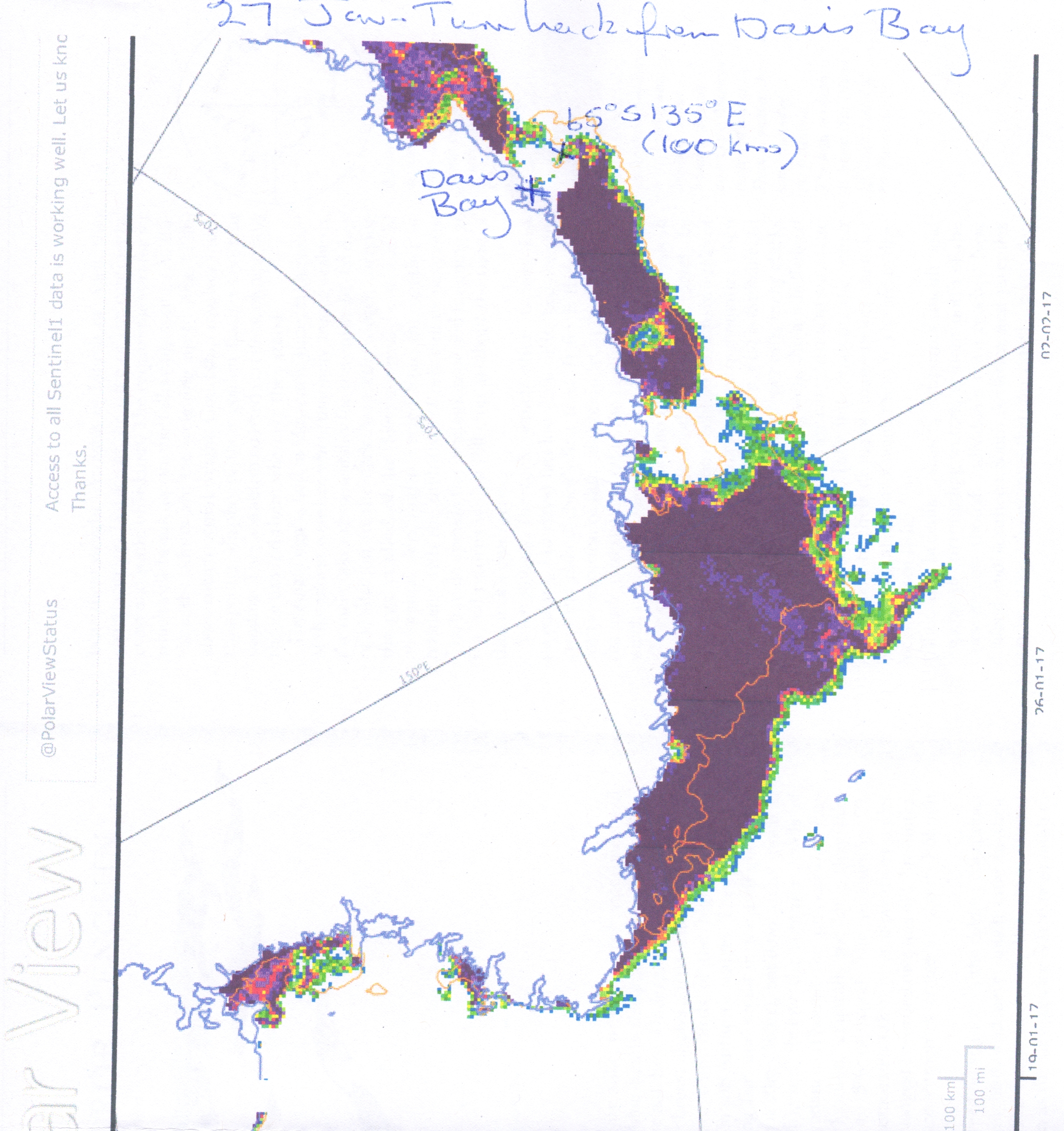 or another one, access Polar View here
Polar View delivers information about sea ice and icebergs direct to ships operating in the Southern Ocean. We use several types of satellite imagery to deliver a comprehensive, detailed and up to date picture of sea ice extent and distribution.
ACE – Antarctic Climate & Ecosystem CRC: TECHNICAL REPORT Sea ice reports for the Antarctic shipping season 2016 – 2017. Access report to revisit sea ice conditions of East Antarctica
Other Antarctic related sites of interest as background to the trip
Heritage Expeditions
Heritage Expeditions, New Zealand’s own award winning Antarctic expedition company, travels south to the Ross Sea each southern summer. The company shares its philosophy of creating advocates for the environments visited on its voyages through the Sub Antarctic and Antarctic regions. Small groups, qualified leadership, maximum time ashore and sensitively managed wildlife interactions.
IAATO: International Association of Antarctica Tour Operators
Heritage Expeditions is a founding member of the International Association of Antarctica Tour Operators. The Antarctic Treaty Parties come together once a year at the Antarctic Treaty Consultative Meeting (ATCM). As an invited Expert since 1992, IAATO participates in annual ATCMs, providing expert advice on tourism-related issues. In its role as representative for the Antarctic tourism industry, IAATO also submits Information Papers and contributes to discussions by the Antarctic Treaty party delegates.
ASOC: Antarctic and Southern Ocean Coalition
ASOC: Antarctica is the world’s most extreme continent – the coldest, driest, and windiest – yet is the home or feeding grounds for millions of penguins, whales, and seals. Its breathtaking scenery often renders visitors speechless. It is the “last continent,” that is, the only remaining continent without a significant human presence or widespread impact on the environment. We urge you to learn more about this unique place and how you can help us ensure that the Antarctic and its magnificent species receive the highest level of environmental protection possible.
The Last Ocean Trailer: Established in 2001, Antarctic Ecologist Dr David Ainley heads this group of leading scientists concerned about the effects fishing on the Ross Sea ecosystem. Over the years FORSE has provided sound scientific advice to political bodies like SCAR (Scientific Committee for Antarctic Research), CCAMLR (Convention for Conservation of Antarctic Marine Living Resources), IWC (International Whaling Commission) and CEP (Committee for Environmental Protection). FORSE provides the scientific foundation for the Last Ocean community.
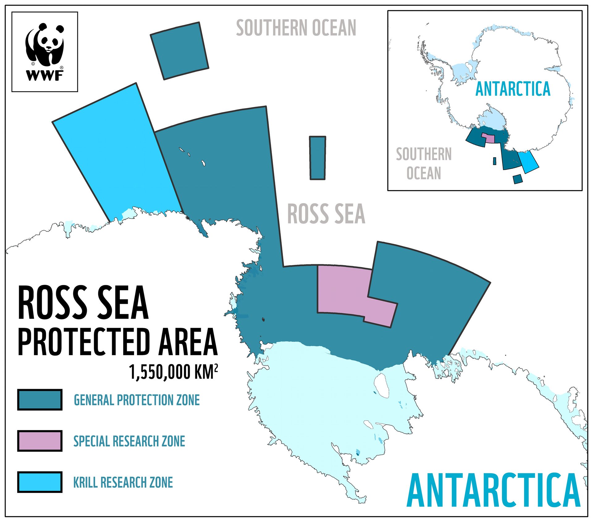 Some Good News! 28 October 2016, The Guardian, A landmark international agreement to create the world’s largest marine park in the Southern Ocean has been brokered in Australia, after five years of compromises and failed negotiations.
More than 1.5m sq km of the Ross Sea around Antarctica will be protected under the deal brokered between 24 countries and the European Union. It means 1.1m sq km of it – an area about the size of France and Spain combined – will be set aside as a no-take “general protection zone”, where no fishing will be allowed. Significantly, the protections are set to expire in 35 years. The agreement came on Friday at the conclusion of two weeks of discussions between delegates from 24 countries and the EU in Hobart, at the annual meeting of the Commission for the Conservation of Antarctic Marine Living Resources (CCAMLR). For more details go here The agreement came into force on 1 December 2016.
 The Antarctic Treaty was signed in Washington on 1 December 1959 by the twelve countries whose scientists had been active in and around Antarctica during the International Geophysical Year (IGY) of 1957-58. It entered into force in 1961 and has since been acceded to by many other nations. The total number of Parties to the Treaty is now 53. The current treaty expires in 2048.
Some important provisions of the Treaty:
-
- Antarctica shall be used for peaceful purposes only (Art. I)
-
- Freedom of scientific investigation in Antarctica and cooperation toward that end … shall continue (Art. II).
- Scientific observations and results from Antarctica shall be exchanged and made freely available (Art. III).
Among the signatories of the Treaty were seven countries – Argentina, Australia, Chile, France, New Zealand, Norway and the United Kingdom – with territorial claims , sometimes overlapping. Other countries do not recognize any claims. The US and Russia maintain a “basis of claim”. All positions are explicitly protected in Article IV, which preserves the status quo:
No acts or activities taking place while the present Treaty is in force shall constitute a basis for asserting , supporting or denying a claim to territorial sovereignty in Antarctica or create any rights of sovereignty in Antarctica. No new claim, or enlargement of an existing claim to territorial sovereignty in Antarctica shall be asserted while the present Treaty is in force.